File:Corp of Eng. 6-16-11A 267.JPG - Wikipedia
 Article Images

Original file (3,872 × 2,592 pixels, file size: 4.68 MB, MIME type: image/jpeg)
File history
Click on a date/time to view the file as it appeared at that time.
| Date/Time | Thumbnail | Dimensions | User | Comment | |
|---|---|---|---|---|---|
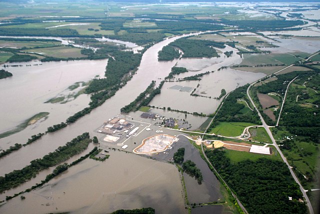
| current | 03:28, 22 June 2011 | | 3,872 × 2,592 (4.68 MB) | Americasroof | {{Information |Description ={{en|1=Aerial view of Fort Calhoun Nuclear Reactor during 2011 Missouri River Flood on June 16, 2011}} |Source =http://www.nwo.usace.army.mil/html/op-e/Photos/Mo%20River%20Rulo%20to%20Blair%2016%20June%202011/NE-Blai |
File usage
The following 9 pages use this file:
Global file usage
This file contains additional information, probably added from the digital camera or scanner used to create or digitize it.
If the file has been modified from its original state, some details may not fully reflect the modified file.
| Camera manufacturer | NIKON CORPORATION |
|---|---|
| Camera model | NIKON D200 |
| Exposure time | 1/2,000 sec (0.0005) |
| F-number | f/3.8 |
| ISO speed rating | 400 |
| Date and time of data generation | 09:59, 16 June 2011 |
| Lens focal length | 22 mm |
| Altitude | 1,218 meters above sea level |
| Horizontal resolution | 300 dpi |
| Vertical resolution | 300 dpi |
| Software used | Ver.1.00 |
| File change date and time | 09:59, 16 June 2011 |
| Y and C positioning | Co-sited |
| Exposure Program | Aperture priority |
| Exif version | 2.21 |
| Date and time of digitizing | 09:59, 16 June 2011 |
| Image compression mode | 4 |
| Exposure bias | 0 |
| Maximum land aperture | 3.8 APEX (f/3.73) |
| Metering mode | Center weighted average |
| Light source | Unknown |
| Flash | Flash did not fire |
| DateTime subseconds | 90 |
| DateTimeOriginal subseconds | 90 |
| DateTimeDigitized subseconds | 90 |
| Color space | sRGB |
| Sensing method | One-chip color area sensor |
| Custom image processing | Normal process |
| Exposure mode | Auto exposure |
| White balance | Auto white balance |
| Digital zoom ratio | 1 |
| Focal length in 35 mm film | 33 mm |
| Scene capture type | Standard |
| Contrast | Normal |
| Saturation | Normal |
| Sharpness | Normal |
| Subject distance range | Unknown |
| Unique image ID | e02c1456e31c73c3e1a81ef75b26ce8a |
| North or south latitude | North latitude |
| East or west longitude | West longitude |
| Satellites used for measurement | 09 |
| Geodetic survey data used | WGS 84 |
| GPS date | 16 June 2011 |