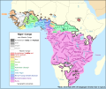
File:Map of the Atlantic–Congo languages.svg - Wikipedia
 Article Images
Original file (SVG file, nominally 1,342 × 1,123 pixels, file size: 1.07 MB)
File history
Click on a date/time to view the file as it appeared at that time.
| Date/Time | Thumbnail | Dimensions | User | Comment | |
|---|---|---|---|---|---|
| current | 20:57, 1 June 2018 |  | 1,342 × 1,123 (1.07 MB) | SUM1 | Added note and fixed key |
| 15:20, 18 July 2017 |  | 1,342 × 1,123 (1.07 MB) | SUM1 | Fixed southern Bantu boundary | |
| 22:00, 15 July 2017 |  | 1,342 × 1,123 (1.08 MB) | SUM1 | Fixed Adamawa–Ubangi boundary | |
| 21:23, 12 July 2017 |  | 1,342 × 1,123 (1.04 MB) | SUM1 | Added thin border around non-Atlantic–Congo shading | |
| 22:33, 10 July 2017 |  | 1,342 × 1,123 (1.04 MB) | SUM1 | Added boundary around Ijoid | |
| 21:10, 10 July 2017 |  | 1,342 × 1,123 (1.04 MB) | SUM1 | Fixed Kordofanian labels | |
| 19:54, 10 July 2017 |  | 1,342 × 1,123 (1.04 MB) | SUM1 | Added border around shading | |
| 15:58, 10 July 2017 |  | 1,342 × 1,123 (1.01 MB) | SUM1 | Fixed Bantu and Adamawa–Ubangi boundaries | |
| 01:08, 10 July 2017 |  | 1,342 × 1,123 (1.01 MB) | SUM1 | Changed "classifications" to "groupings" | |
| 01:03, 10 July 2017 |  | 1,342 × 1,123 (1.01 MB) | SUM1 | Combined uncombined paths and fixed colour |
File usage
The following 2 pages use this file:
Global file usage
The following other wikis use this file:
- Usage on es.wikipedia.org
- Usage on fa.wikipedia.org
- Usage on ha.wikipedia.org
- Usage on id.wikipedia.org
- Usage on it.wikipedia.org
- Usage on lt.wikipedia.org
- Usage on tr.wikipedia.org
- Usage on vi.wikipedia.org
- Usage on zh.wikipedia.org
This file contains additional information, probably added from the digital camera or scanner used to create or digitize it.
If the file has been modified from its original state, some details may not fully reflect the modified file.
| Short title | Blank map of the African continent |
|---|---|
| Width | 1341.8438 |
| Height | 1122.6584 |
