Kurima-jima
Contributors to Wikimedia projects
 Article Images
This article needs additional citations for verification. Please help improve this article by adding citations to reliable sources. Unsourced material may be challenged and removed.
Find sources: "Kurima-jima" – news · newspapers · books · scholar · JSTOR (January 2021) (Learn how and when to remove this message)
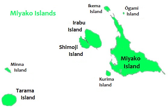
Kurima Island (来間島, Kurima-jima), (Miyako: Ffyama) is one of the Miyako Islands of Okinawa Prefecture, Japan.[1]: 3 It is connected to the southeastern end of the Yonaha Maehama beach on the Miyako-jima island via 1,690 metres (1.05 mi) Kurima Bridge (来間大橋), which was opened on 13 March 1995.[1]: 6 [2]
Japanese: 来間島 | |
|---|---|
 Kurima-jima is located 1.5 km southwest of Miyako-jima | |
Kurima Island | |
| Geography | |
| Location | Okinawa Prefecture |
| Coordinates | 24°43′20.47″N 125°14′49.10″E / 24.7223528°N 125.2469722°E |
| Archipelago | Miyako Islands |
| Area | 2.84 km2 (1.10 sq mi)[1]: 2 |
| Administration | |
Japan | |
| Okinawa Prefecture | |
| Demographics | |
| Population | 161 (2015 national census)[1]: 13 |
| Ethnic groups | Ryukyuan, Japanese |

Gallery
-
Kurima-jima
-
Bridge from Kurima-jima to Miyako-jima
-
Beach on Kurima island
See also
References
- ^ a b c d "Remote island related materials (離 島 関 係 資 料)" (PDF). Archived (PDF) from the original on 15 February 2020. Retrieved 15 February 2020.
- ^ "Kurima-ohashi Bridge | Miyakojima | Japan Travel Guide - Japan Hoppers". Archived from the original on 27 August 2019.
External links
Wikimedia Commons has media related to Kurima Island.
Wikivoyage has a travel guide for Miyako Islands.
This Okinawa Prefecture location article is a stub. You can help Wikipedia by expanding it. |