File:Map Roumanophone World.png - Wikimedia Commons
 Article Images

Original file (1,357 × 628 pixels, file size: 35 KB, MIME type: image/png)
File information
Structured data
Captions
Captions
Add a one-line explanation of what this file represents
| Description |
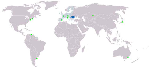
English: Map of the Roumanophone World (Romanian is an official and working language of the EU). Legend:
Italiano: La mappa mostra la distribuzione geografica della lingua rumena. Legenda:
Polski: Legenda:
Română: Legendă:
|
| Date | Originally uploaded in 2006 |
| Source | Own work |
| Author | Originally uploaded by User:Danutz |
File history
Click on a date/time to view the file as it appeared at that time.
| Date/Time | Thumbnail | Dimensions | User | Comment | |
|---|---|---|---|---|---|
| current | 09:21, 7 March 2018 | | 1,357 × 628 (35 KB) | Maphobbyist (talk | contribs) | Montenegro and South Sudan borders |
| 17:29, 1 September 2013 |  | 1,357 × 628 (52 KB) | Loránd Salvan (talk | contribs) | Croatia a aderat la uniunea Europeana . | |
| 03:25, 23 November 2010 |  | 1,357 × 628 (29 KB) | CoolDuder69 (talk | contribs) | Added Japanese Romanian Minority and better compression | |
| 18:57, 17 January 2007 |  | 1,357 × 628 (45 KB) | Danutz (talk | contribs) | ||
| 22:12, 6 January 2007 |  | 1,357 × 628 (45 KB) | Danutz (talk | contribs) | ||
| 20:53, 5 January 2007 |  | 1,357 × 628 (25 KB) | Romihaitza (talk | contribs) | Update with EU | |
| 15:14, 28 May 2006 |  | 1,357 × 628 (45 KB) | Danutz (talk | contribs) | Map of the Roumanophone World. Dark blue: National and official language Blue: Official language Lightblue: National minority language Green square: Minority |
You cannot overwrite this file.
File usage on Commons
File usage on other wikis
The following other wikis use this file:
- Usage on af.wikipedia.org
- Usage on ang.wikipedia.org
- Usage on an.wikipedia.org
- Usage on ar.wikipedia.org
- Usage on ary.wikipedia.org
- Usage on arz.wikipedia.org
- Usage on ast.wikipedia.org
- Usage on ba.wikipedia.org
- Usage on be.wikipedia.org
- Usage on bn.wikipedia.org
- Usage on ca.wikipedia.org
- Usage on ce.wikipedia.org
- Usage on cs.wikipedia.org
- Usage on cu.wikipedia.org
- Usage on de.wikivoyage.org
- Usage on diq.wikipedia.org
- Usage on dsb.wikipedia.org
- Usage on en.wikipedia.org
- Usage on et.wikipedia.org
- Usage on eu.wikipedia.org
- Usage on fa.wikipedia.org
- Usage on fr.wikipedia.org
- Usage on fur.wikipedia.org
- Usage on ga.wikipedia.org
- Usage on gd.wikipedia.org
- Usage on gl.wikipedia.org
- Usage on gv.wikipedia.org
- Usage on hak.wikipedia.org
- Usage on hsb.wikipedia.org
- Usage on ia.wikipedia.org
- Usage on ie.wikipedia.org
- Usage on ilo.wikipedia.org
- Usage on incubator.wikimedia.org
- Usage on it.wikipedia.org
- Usage on ja.wikipedia.org
- Usage on kk.wikipedia.org
- Usage on km.wikipedia.org
- Usage on lo.wikipedia.org
- Usage on lv.wikipedia.org
- Usage on mhr.wikipedia.org
- Usage on mk.wikipedia.org
- Usage on ml.wikipedia.org
- Usage on mr.wikipedia.org
- Usage on ms.wikipedia.org
- Usage on mzn.wikipedia.org
- Usage on no.wikipedia.org
View more global usage of this file.
Metadata
This file contains additional information such as Exif metadata which may have been added by the digital camera, scanner, or software program used to create or digitize it. If the file has been modified from its original state, some details such as the timestamp may not fully reflect those of the original file. The timestamp is only as accurate as the clock in the camera, and it may be completely wrong.
| Horizontal resolution | 37.8 dpc |
|---|---|
| Vertical resolution | 37.8 dpc |
| Software used |