 Article Images
district in Bavaria, Germany
part of Oberfranken << Bayern << ![]() Germany
Germany
-

-
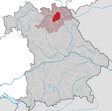
Lage im Regierungsbezirk Oberfranken / in Bayern
-
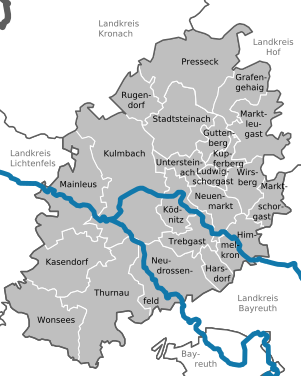
Kartierung aller Kommunen


district in Bavaria, Germany
| |||||
| Upload media | |||||
| Instance of |
| ||||
|---|---|---|---|---|---|
| Location | Upper Franconia, Bavaria, Germany | ||||
| Capital | |||||
| Head of government |
| ||||
| Inception |
| ||||
| Population |
| ||||
| Area |
| ||||
| Elevation above sea level |
| ||||
| official website | |||||
 50° 05′ 12″ N, 11° 23′ 50.23″ E 50° 05′ 12″ N, 11° 23′ 50.23″ E | |||||
| |||||


Große Kreisstadt
-
Lage
-
Wappen
-
Rathaus
-
Plassenburg
Main category: Plassenburg
-
Burghof
Main category: Kupferberg
-
Lage
-
Wappen
-
katholische Stadtpfarrkirche St. Veit
-
ehem. Spital mit katholischer Kirche zum Heiligen Geist und St. Katharina; Felsenkeller
-
Besucherberkwerk
Main category: Stadtsteinach
-
Lage
-
Wappen
-
Luftbild
-
Ortsmitte
-
Marktbrunnen
-
Burgruine Nordeck
Main category: Grafengehaig
-
Lage
-
Wappen
-
Lage
-
Wappen
-
Rathaus
Main category: Ludwigschorgast
-
Lage
-
Wappen
-
St. Bartholomäus
-
Lage
-
Wappen
-
Schloss Wernstein
-
Schloss Buchau
Main category: Marktleugast
-
Lage
-
Wappen
-
Hauptplatz
Main category: Marktschorgast
-
Lage
-
Wappen
-
Marktplatz
-
Lage
-
Wappen
-
Marktplatz
-
Lage
-
Wappen
-
Schloss mit Übergang zur St.-Laurentius-Kirche
-
Schloss Thurnau mit dem Brückengang zur St.-Laurentius-Kirche
-
St.-Laurentius-Kirche
-
Patronatsloge der St.-Laurentius-Kirche
-
St.-Georg-Kirche in Berndorf
-
Empore der St.-Georg-Kirche
-
Lage
-
Wappen
-
Lage
-
Wappen
-
Guttenberg
Main category: Guttenberg
-
Himmelkron
Main category: Himmelkron
-
Neudrossenfeld
Main category: Neudrossenfeld
-
Neuenmarkt
Main category: Neuenmarkt
-
Untersteinach
Main category: Untersteinach
This is a gallery page containing specially selected image and media files. They have been chosen as highlights of a particular topic, but do not represent the full range of files that are available on Commons. For a wider selection of files connected with Landkreis Kulmbach, see Category:Landkreis Kulmbach.