Mount Ararat
ウィキメディアプロジェクトへの貢献者
 Article Images
English: Mount Ararat (Turkish: Ağrı Dağı, Armenian: Արարատ, Greek: Αραράτ, Hebrew: אררט, Kurdish: Agirî, Persian: آرارات) is located in extreme northeast Turkey, close to the borders of Armenia, Azerbaijan, and Iran. Ararat consists of two volcanic peaks: Big Ararat (5,137 m) and Little Ararat (3,914 m). No eruptions of Mt. Ararat have ever been recorded, but the mountain is likely to have erupted within the past 10,000 years. Located far from any plate boundaries, the underlying cause of volcanism at Mt. Ararat is not well understood.
Türkçe: Ağrı Dağı (Selçuklular döneminde; Eğri Dağ, resmi adıyla Büyük Ağrı Dağı), Türkiye'nin en yüksek dağıdır.
Հայերեն: Արարատ (թուրք.՝ Ağrı Dağı, քրդ.՝ Çiyayê Agirî), հանգած հրաբուխ Հայաստանի, Իրանի և Թուրքիայի սահմանի մոտ՝ Արաքս գետի աջ ափին, ներկա սահմանից 32 կմ հեռավորության վրա, իսկ Իրանի սահմանից՝ 16 կմ։
Kurdî: Çiyayê Agirî an Grîdax, ji serdema navîn a dawî ve navên Çiyayê Agirî tê bikaranîn. Navê çiyayê di kevneşopiya kurdî de bi navê Koşaxî an jî Çiyayê Şaxî hatiye bi navkirin. Navê çiyê di kurdî ya îro de Çiyayê Agirî ye. Ev nav tê wateya "çiyayê bi agir" yan jî "çiyayê agrîn".
-
Mount Ararat in July 2007 with Khor Virap monastery in the foreground.
-
A distant view to Khor Virap monastery with Mount Ararat visible in the mist at the left
-
Mount Ararat from Ararat Plain
-
A distant view of Khor Virap monastery with Mount Ararat
-
Two volcanic cones of Ararat
-
Mount Ararat, Turkey.
-
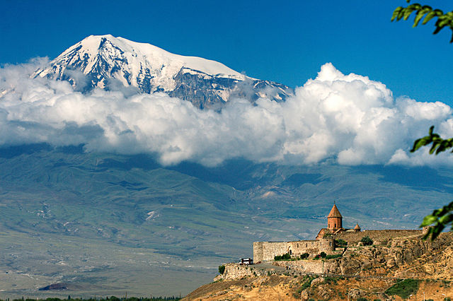
Khor Virap monastery in front of Mount Ararat
-
Yerevan with Mount Ararat in the background during winter (March)
-
Yerevan with Mount Ararat in the background during late spring (May) 1
-
Yerevan with Mount Ararat in the background during late spring (May) 2
-
A clear picture of Ararat Mountain from Yerevan
-
Yerevan with Mount Ararat during sunset
-
Mount Ararat visible above the clouds 1
-
Mount Ararat visible above the clouds 2
-
Mount Ararat visible above the clouds 3
-
Mount Ararat seen from east of Doğubayazıt, Turkey in summer
-
Mount Ararat seen from Turkey in summer
-
Mount Ararat seen from Turkey in late spring (May)
-
Mount Ararat seen from Iğdır, Turkey in summer
-
Mount Ararat seen from Iğdır, Turkey in summer
-
Mount Ararat seen from Iğdır, Turkey in summer
-
Mount Ararat seen from Iğdır, Turkey in summer
-
Mount Ararat seen from an airplane in Turkey during summer 1
-
Mount Ararat seen from an airplane in Turkey during summer 2
-
Mount Ararat seen from an airplane in Nakhchivan, Azerbaijan
-
Mount Ararat seen from Akhamed willage of Sharur region in Nakhchivan, Azerbaijan during early spring (March)
Only two climbing routes are open for climbing. North, igdir Route and South East is dogubeyazit
-
Ararat with village
-
Top from village below
-
Ararat and truck loaded with mounteners
-
View at plato below(around 4000m)
-
Look at small Ararat(around 4000m)
-
Horses carring bagage(around 4000m)
-
Base camp at 4200m
-
Base camp at 4200m
-
Climbing route at 4700m
-
Snow covered top from 4900m
-
View at the top from 2700m
Taken from a Space Shuttle
-
Image taken from a Space Shuttle
-
Computer generated image of Mount Ararat, courtesy NASA
-
Computer generated image
-
modified satellite image
-
A depiction of Mt. Ararat on the coat of Arms of Armenia
-
"Martyrdom of the Ten Thousand of Mount Ararat" by Vittore Carpaccio.
-
Noah's Ark on the Ararat peak
-
Location map of Mount Ararat in the extreme east of Turkey