 Article Images
body of water in Chile connecting Atlantic and Pacific Oceans
English: The Strait of Magellan is a navigable route immediately south of mainland South America. Located between the continent and Tierra del Fuego, and Cape Horn to the south, the strait is arguably the most important natural passage between the Pacific and the Atlantic oceans.
Español: Estrecho de Magellanes es una ruta navegable contigua al continente sudamericano. Ubicado entre el continente y Tierra del Fuego, y Cabo de Hornos al sur, el estrecho es el paso más importante entre los océanos Pacífico y Atlántico.
智利南部的一个海峡
| |||||
| 上传媒体 | |||||
| 隶属于 | |||||
|---|---|---|---|---|---|
| 名称由来 | |||||
| 位置 | 麦哲伦-智利南极大区, 智利 | ||||
| 發現者或發明者 | |||||
| 流入源 |
| ||||
 54° 00′ 00″ 南, 71° 00′ 00″ 西 54° 00′ 00″ 南, 71° 00′ 00″ 西 | |||||
| |||||


-

Battista Agnese - Detail from a world map showing Strait of Magellan (1544)
-

Jodocus Hondius - Strait of Magellan (north and south reversed)
-

Map showing the strait of Magellan
-

Willem Blaeu - Tabula Magellanica 1635
-

FRETI MAGELLANICI ac novi FRETI vulgo LE MAIRE exactissima delineatio: A map of Strait of Magellan and Tierra del Fuego by Jodocus Hondius
-
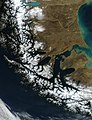
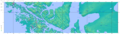
Satellite image of the strait of Magella, courtesy NASA
-
-

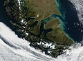
A view from the northern shore
-

The northern shore
-

The southern shore
-

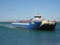
Melinka cruising between Punta Arenas and Porvenir
-
Pionero cruising the frequent route between Punta Delgada and Punta Espora
-

Fuegino cruising the frequent route between Punta Delgada and Punta Espora
-
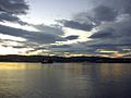
sunset view
-

sunrise view
-

Topography and Toponymy between latitude 52°S and 53°S
-
Topography and Toponymy between latitude 53°S and 54°S
-
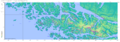
Topography and Toponymy between latitude 54°S and 55°S
-

Topography and Toponymy between latitude 56°S and 54°40"S


