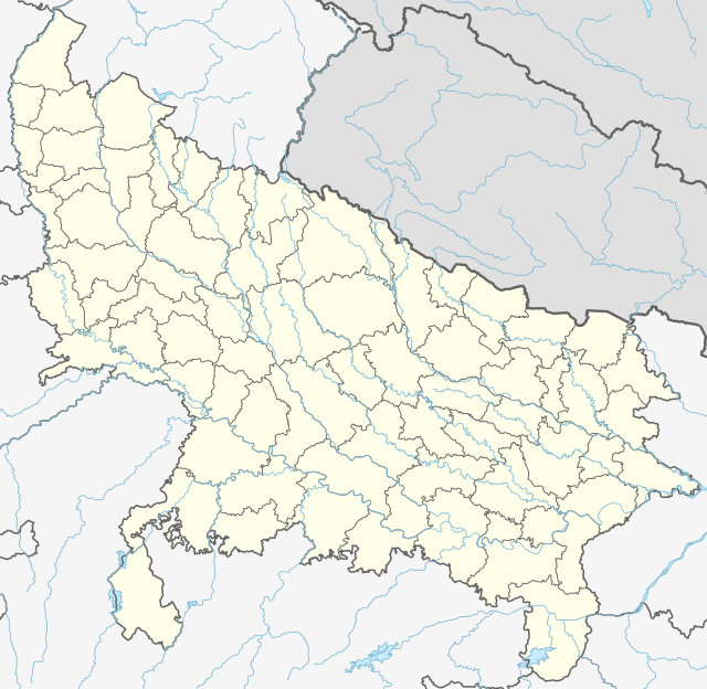
File:India Uttar Pradesh location map.svg - Wikipedia
 Article Images
Original file (SVG file, nominally 1,006 × 981 pixels, file size: 776 KB)
File history
Click on a date/time to view the file as it appeared at that time.
| Date/Time | Thumbnail | Dimensions | User | Comment | |
|---|---|---|---|---|---|
| current | 06:40, 1 May 2023 |  | 1,006 × 981 (776 KB) | C1MM | c borders |
| 04:44, 5 January 2022 |  | 1,066 × 927 (777 KB) | C1MM | Corrected rivers and dist boundaries | |
| 22:54, 12 February 2021 |  | 909 × 886 (262 KB) | C1MM | Added Chhattisgarh | |
| 00:41, 8 January 2021 |  | 909 × 886 (261 KB) | C1MM | Added Amethi district | |
| 21:29, 22 April 2020 |  | 909 × 886 (249 KB) | NordNordWest | Reverted to version as of 19:51, 9 October 2012 (UTC); no need to change colours | |
| 21:00, 22 April 2020 |  | 909 × 886 (292 KB) | C1MM | Fixed rivers | |
| 20:51, 22 April 2020 |  | 909 × 886 (290 KB) | C1MM | Fixed colors and made rivers along borders | |
| 19:51, 9 October 2012 |  | 909 × 886 (249 KB) | NordNordWest | =={{int:filedesc}}== {{Information |Description= {{de|Positionskarte von Uttar Pradesh, Indien}} Quadratische Plattkarte, N-S-Streckung 112 %. Geographische Begrenzung der Karte: * N: 30.5° N * S: 23.8° N * W: 77.... |
File usage
More than 100 pages use this file. The following list shows the first 100 pages that use this file only. A full list is available.
- Aligarh
- Amroha
- Auras, Uttar Pradesh
- Ayodhya
- Azamgarh
- Baberu
- Babina, Uttar Pradesh
- Baghpat
- Bahraich
- Ballia
- Balrampur
- Banda, Uttar Pradesh
- Bara Imambara
- Barabanki
- Bareilly
- Barel
- Bijnor
- Bilari
- Bilaspur, Uttar Pradesh
- Bithoor
- Budaun
- Bulandshahr
- Chandauli
- Chandausi
- Charkhari
- Chauri Chaura
- Chunar
- Dainik Jagran
- Deoband
- Dudhwa National Park
- Etah
- Etawah
- Faizabad
- Farrukhabad
- Fatehgarh
- Fatehpur Sikri
- Firozabad
- Ghaziabad
- Ghazipur
- Gokul
- Gonda, Uttar Pradesh
- Gorakhpur
- Govardhan
- Gyanpur
- Hamirpur, Uttar Pradesh
- Hapur
- Hardoi
- Hathras
- Izzatnagar
- Jalaun
- Jarwa
- Jaunpur, Uttar Pradesh
- Jhansi
- Kalpi
- Kalyanpur, Uttar Pradesh
- Kanpur
- Kashi Vishwanath Temple
- Kemri
- Khalilabad, India
- Kheri
- Khurja
- Korwa, Uttar Pradesh
- Kulpahar
- Kurara
- Lalitpur, India
- Lucknow
- Mahoba
- Mainpuri
- Mau, Uttar Pradesh
- Mauranipur
- Maya Bazar, Ayodhya
- Meerut
- Mehnajpur
- Mirzapur
- Modinagar
- Moradabad
- Mubarakpur, Azamgarh
- Mursan
- Muzaffarnagar
- Nagina
- Nagwa
- Najibabad
- Nakur
- Narora
- Noida
- Orai
- Pilibhit
- Pratapgarh, Uttar Pradesh
- Prayagraj Airport
- Raebareli
- Ram Janmabhoomi
- Robertsganj
- Saharanpur
- Sardhana
- Shahjahanpur
- Sitapur
- Sultanpur, Uttar Pradesh
- Taj Mahal
- Unnao
- Vrindavan
View more links to this file.
Global file usage
The following other wikis use this file:
- Usage on ar.wikipedia.org
- Usage on as.wikipedia.org
- Usage on awa.wikipedia.org
- Usage on azb.wikipedia.org
- اتاوه
- کینتور
- علیپورا
- فولپور
- فولی (هیندوستان)
- ففنا (هیندوستان)
- فارندا
- سارسای ناوار
- ساروخیپورا
- ساراوان, جاونپور
- ساراسارا, یوتار پرادش
- ساراییا بور
- سارایبیرو
- مداوارا کالا
- سانخنی
- ماوجامپور
- ماسکانوا
- سانای, بوداون
- سامرر (هیندوستان)
- کالاند, ایندیا
- مارتین پوروا
- سامبالهرا
- کاکورا
- سالارپور, بوداون
- کایتورا, جاونپور
- ساییان, آقرا
- ساینتال, یوتار پرادش
- سایفای
- کاقارول
- سایدناقار
- ساهاجانپور
- هالاور
- سافدارقانج
- سادپور, یوتار پرادش
- روپایدیها
- رابارلی
- کادار چووک
- سادارپور
- سابالپور
View more global usage of this file.
This file contains additional information, probably added from the digital camera or scanner used to create or digitize it.
If the file has been modified from its original state, some details may not fully reflect the modified file.
| Width | 283.95963mm |
|---|---|
| Height | 276.73572mm |
