1873 Atlantic hurricane season: Difference between revisions - Wikipedia
 Article Images
Line 1:
{{Short description|Hurricanenone}} season<!-- in"none" is a legitimate description when the Atlantictitle Ocean}}is already adequate; see [[WP:SDNONE]] -->
{{Infobox hurricane season full
| Basin= Atl
Line 20:
}}
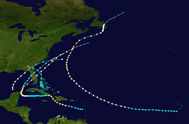
The '''1873 Atlantic hurricane season''' was quiet, featuring only five known [[tropical cyclone]]s, but all of them made [[landfall]], causing significant impacts in some areas of [[Atlantic hurricane|the basin]]. Of these five systems, three intensified into a hurricane, while two of those attained [[Saffir-Simpson Hurricane Scale#Category 3|major hurricane]] status.{{refn|A major hurricane is a storm that ranks as Category 3 or higher on the [[Saffir–Simpson hurricane wind scale]].<ref name="ACE">{{cite report|work=[[Hurricane Research Division]]; [[Atlantic Oceanographic and Meteorological Laboratory]]|publisher=[[National Oceanic and Atmospheric Administration]]|date=April 2023|title=North Atlantic Hurricane Basin (1851-2022) Comparison of Original and Revised HURDAT|access-date=April 8, 2024|url=http://www.aoml.noaa.gov/hrd/hurdat/comparison_table.html|location=Miami, Florida}}</ref>|group="nb"}} However, in the absence of modern satellite and other remote-sensing technologies, only storms that affected populated land areas or encountered ships at sea were recorded, so the actual total could be higher. An undercount bias of zero to six tropical cyclones per year between 1851 and 1885 and zero to four per year between 1886 and 1910 has been estimated.<ref>{{cite book |title=Hurricanes and Typhoons: Past, Present and Future |chapter=The Atlantic hurricane database re-analysis project: Documentation for the 1851–1910 alterations and additions to the HURDAT database|last=Landsea|first=Christopher W. |editor=Murname, Richard J.|editor2=Liu, Kam-biu|year=2004 |publisher=Columbia University Press |location=New York City, New York|url=https://wwwbooks.google.com/books/edition/Hurricanes_and_Typhoons/4jC6ljADbsIC?hlid=en&gbpv=14jC6ljADbsIC&bsqq=1851%20to%201885%20%22four%22|isbn=0-231-12388-4 |page=195|accessdate=March 16, 2024}}</ref>
Of the known cyclones, large alterations were made to the tracks of Hurricane Twosecond and Hurricanefifth Fivesystems in 1995 by José Fernández-Partagás and Henry Diaz, who also proposed smaller changes to the known track of Hurricanethird Threesystem.<ref name="PD1995b">{{cite report|author=Fernández-Partagás, José|author2=Diaz, Henry F.|date=1995|title=A Reconstruction of Historical Tropical Cyclone Frequency in the Atlantic from Documentary and other Historical Sources: 1851–1880 Part II: 1871–1880|url=https://www.aoml.noaa.gov/hrd/Landsea/Partagas/1871-1876/1873.pdf|publisher=Climate Diagnostics Center, National Oceanic and Atmospheric Administration|accessdate=December 18, 2023}}</ref> Neither Fernández-Partagás and Diaz nor the [[Atlantic hurricane reanalysis project]] introduced any previously undocumented tropical cyclones during their reanalyses of the 1873 season. Another reanalysis study, authored by climate researcher Michael Chenoweth and published in 2014, theorizes that six cyclones formed. Chenoweth proposes the removal of the first and fourth storms from the [[HURDAT|official hurricane database]] (HURDAT), as well as the addition of three new storms. However, these changes have yet to be incorporated into HURDAT.
The season's first known cyclone was initially observed near [[Andros]] island in [[the Bahamas]] on June 1. After crossing [[Grand Bahama]], the cyclone moved northwestward and struck [[Georgia (U.S. state)|Georgia]] on the next day, leaving minimal damage. More than two months passed before the track for the next storm began on August 13. After nearly two weeks at sea, the hurricane extensively impacted [[Atlantic Canada]], with at least 223 fatalities in the region and about $3.5 million (1873 USD) in damage.{{#tag:ref|All damage figures are in 1873 [[USD]], unless otherwise noted|group="nb"}} Three more storms developed in September, the first of which struck near [[St. Marks, Florida|St. Marks]], [[Florida]], on September 19, causing more than $550,000 in damage and at least three deaths, mostly over the eastern [[Florida Panhandle]]. The season's final known storm was detected over the eastern [[Caribbean Sea]] on September 26 and transitioned into an [[extratropical cyclone]] on October 9. The cyclone struck [[Haiti]], [[Cuba]], and Florida at hurricane intensity, killing at least 26 people and leaving a substantial but unknown amount of damage. Overall, the storms of the 1873 season caused at least 252 deaths and more than $4.055 million in damage.
Line 138:
}}
A hurricane was first observed in the south-central Gulf of Mexico on September 18. It moved quickly northeastward, striking [[St. Marks, Florida]], around 15:00 UTC on September 19.{{Atlantic hurricane best track}} The Atlantic hurricane reanalysis project estimated in 2011 that the storm had a barometric pressure of {{convert|982|mbar|inHg|abbr=on}} upon landfall, along with sustained winds of 80 mph (130 km/h).<ref name="meta">{{cite report|url=http://www.aoml.noaa.gov/hrd/hurdat/metadata_master.html#1873_1|title=Documentation of Atlantic Tropical Cyclones Changes in HURDAT|author=Landsea, Christopher W. |work=Atlantic Oceanographic and Meteorological Laboratory|publisher=National Oceanic and Atmospheric Administration|accessdate=December 18, 2023|location=Miami, Florida|display-authors=etal}}</ref> Moving inland, the [[eye (cyclone)|eye]] of the storm passed over [[Tallahassee, Florida|Tallahassee]], attended by an hour-long calm. Sustained winds in town were unofficially estimated at up to {{convert|100|mi/h|km/h|abbr=on}}.<ref name="ellis"/>{{rp|489, 495}} Later on September 19, the system weakened to a tropical storm as it entered [[Georgia (U.S. state)|Georgia]]. The storm then crossed into South Carolina early the next day and soon emerged into the Atlantic.{{Atlantic hurricane best track}} Based on ship reports,<ref name="PD1995b"/>{{rp|27}} the cyclone likely re-intensified into a hurricane on September 20 but was last noted on that day about {{convert|300|mi|km|abbr=on|round=5}} east of [[North Carolina]].{{Atlantic hurricane best track}} Chenoweth extends the path of this storm back to September 12 over the southeastern [[Caribbean Sea]] and adds one additional day at the end of its duration, with the system accelerating northeastward towards the [[Grand Banks of Newfoundland]].<ref name="Chenoweth"/>
The storm was considered the most severe to affect interior [[North Florida]] between the close of the [[American Civil War]] and the early 1900s.<ref name="ellis"/>{{rp|487–8}} In Florida, only two homes remained standing at St. Marks, leaving twenty families homeless.<ref name="nyt923">{{cite news|url=https://www.newspapers.com/article/the-new-york-times/137055255/|title=Disastorous Storm in Florida|page=5|newspaper=The New York Times|date=September 23, 1873|accessdate=December 18, 2023|via=Newspapers.com}} {{free access}}</ref> The storm demolished about 20 residences in [[Apalachicola, Florida|Apalachicola]] and unroofed approximately twice as many, while also damaging about half of businesses and many vessels in the town. Damage in Apalachicola reached about $250,000.,<ref name="tbdg1008">{{cite news|url=https://www.newspapers.com/article/the-boston-globe/137044041/|title=Details of Recent Storm in Florida|date=October 8, 1873|newspaper=The Boston Daily Globe|page=5|accessdate=December 18, 2023|via=Newspapers.com}} {{free access}}</ref> Fartherand [[Taxodium|cypress]] trees nearby were shorn of their bark, as if "shaved by a knife". Many "substantial" buildings in town were leveled, including 15 brick stores. All the local [[orange (fruit)|orange]] trees were blown down.<ref name="ellis"/>{{rp|490}} The [[Dog Island Light]] was blown apart.<ref name="ellis"/>{{rp|488}} An {{convert|18|ft|m|adj=mid|-high}} [[Storm surge#Measuring surge|storm tide]] inundated St. Marks, and farther south, the hurricane destroyed 12 dwellings on [[Cedar Key, Florida|Cedar Key]].<ref name="ellis"/>{{rp|491}} Strong winds inAt [[TallahasseeSt. Teresa, Florida|TallahasseeSt. Teresa]] the storm felled large trees and destroyed boats.<ref name="ellis"/>{{rp|492}} Strong winds in Tallahassee unroofed several stores and demolished a number of gin houses. Additionally, the storm destroyed 30-4030–40 homes and substantially damaged many others.<ref name="nyt923"/> Among the many other structures suffering damage in Tallahassee was the [[Florida State Capitol]], with floodwaters noted in several sections of the building. The Capitol grounds were littered with trees. Annexes, chimneys, and porches were ripped off homes.<ref name="ellis"/>{{rp|493}} [[Leon County, Florida|Leon County]] alone recorded $100,000 to $200,000 in damage.<ref name="ellis"/>{{rp|495}} ''The New York Times'' reported three or four deaths occurring in the area.<ref name="nyt923"/> Damage in neighboring [[Jefferson County, Florida|Jefferson County]] was estimated at $200,000.<ref name="tbdg1008"/> The eastern [[Florida Panhandle]] suffered a loss of about one-third of its cotton crops, and wind gusts were estimated to have reached {{convert|150|mi/h|km/h|abbr=on}}. Many [[tornado]]es were suspected, their paths marked by sheared-off trees.<ref name="ellis"/>{{rp|495}} In Georgia, heavy rains fell as far north as [[Macon, Georgia|Macon]]. This caused agricultural damage across southern Georgia and washed out railroad tracks, leading to some fatal train accidents.<ref name="ellis"/>{{rp|489}}
{{clear}}
Line 154:
}}
A few days after the previous storm, another storm was observed in the eastern Gulf of Mexico just north of the [[Yucatán Channel]] on September 22. Tracking northeastward, the storm reached sustained winds of 60 mph (95 km/h) before making landfall near present-day [[Madeira Beach, Florida]], around 10:00 UTC on the following day.{{Atlantic hurricane best track}} Little impact occurred, with the ''Tampa Guardian'' only reporting "beating showers and driving winds."<ref name="ellis">{{cite journal|title=North Florida and the Great Storm of 1873|url=https://palmm.digital.flvc.org/islandora/object/ucf%3A25467|jstor=30146596|author=Louise Ellis, Mary|date=April 1984|issn=0015-4113|volume=62|issue=4|journal=The Florida Historical Quarterly|pages=485–496 |accessdate=December 18, 2023}}</ref>{{rp|486}} The cyclone emerged into the Atlantic near [[Palm Coast, Florida|Palm Coast]] late on September 23 and continued rapidly northeastward.{{Atlantic hurricane best track}} Presumably, the schooner ''H. Hulrburt'' made the last encounter with this storm on September 24,<ref name="PD1995b"/>{{rp|28}} with the official track ending about halfway between Bermuda and [[Long Island]], [[New York (state)|New York]], on that day.{{Atlantic hurricane best track}} Chenoweth's reanalysis, published in 2014, proposes removing this cyclone from HURDAT, instead classifying it as a weak frontal boundary.<ref name="Chenoweth"/>
{{clear}}
Line 167:
|Pressure=959
}}
A tropical storm was first seen in the eastern [[Caribbean Sea]] near [[Martinique]] on September 26. The storm moved west-northwestward and likely intensified into a hurricane by the following day. It then moved northwestward, hitting [[Haiti]]'s [[Tiburon Peninsula]] just west of [[Jacmel]] on September 28 with winds of 115 mph (185 km/h). A [[weather station]] at Jacmel registered a barometric pressure of {{convert|28.60|inHg|mb|abbr=on}}, outside the eye. Briefly re-emerging into the Caribbean, the storm struck Cuba near [[Guantánamo Bay]] early the next day, possibly at a weaker intensity. The system then turned westward over southern [[Oriente Province]] and soon weakened to a tropical storm, before again re-entering the Caribbean early on September 30. By October 3, the cyclone re-strengthened into a hurricane over the northwest Caribbean. After curving northward a few days later, the system passed just offshore the [[Yucatán Peninsula]] as it entered the Gulf of Mexico on October 5. Thereafter, the hurricane accelerated northeastward and re-intensified to reach sustained winds of 115 mph (185 km/h) prior to making landfall near [[Punta Rassa, Florida]], early on October 7. The lowest pressure on land was estimated to be {{convert|959|mb|inHg|abbr=on}}, based on observations from Punta Rassa. The system emerged into the Atlantic near present-day [[Melbourne, Florida|Melbourne]] several hours later and continued northeastward until October 9, when it became an extratropical cyclone, which dissipated on the following day.{{Atlantic hurricane best track}}<ref name="Meta">{{cite report|author-first1=Chris|author-last1=Landsea|author-first2=Craig|author-last2=Anderson|author-first3=William|author-last3=Bredemeyer|author-first4=Noel|author-last4=Charles|author-first5=Michael|author-last5=Chenoweth|display-authors=3|author-link1=Christopher Landsea|url=https://www.aoml.noaa.gov/hrd/hurdat/metadata_master.html#1873_5|title=Documentation of Atlantic Tropical Cyclones Changes in HURDAT: 1873/05|website=[[Atlantic hurricane reanalysis project|Re-Analysis Project]]|publisher=[[Atlantic Oceanographic and Meteorological Laboratory]], [[Hurricane Research Division]]|location=[[Miami]], [[Florida]]|accessdate={{date|{{date}}|mdy}}}}</ref><ref name="PD1995b" />{{rp|30}}▼
'''The Central Florida hurricane of 1873'''
In Haiti, severe damage occurred in the Jacmel area, while ''The New York Times'' reported a "considerable loss of life." The storm demolished some 200 homes, downed "immense" trees, and wrecked many vessels in the port. Additionally, Jacmel suffered the total loss of its prison and a church sustained major damage. Similar impacts occurred in the Guantánamo Bay area of Cuba, with a number of vessels beached and many homes being unroofed. The steamer ''Maisi'' capsized near [[Isla de la Juventud]], drowning 24 people. After the storm entered the Gulf of Mexico, the [[Havana]] area reported high tides and strong winds on October 6 and October 7. Waves caused extensive damage to the interior of homes along San Lazaro street and flooded many other roads, reportedly drowning several people. Telegraph lines were downed throughout the island. In Florida, [[Key West]] reported sustained winds of 80 mph (130 km/h), while Punta Rassa observed sustained winds of {{convert|90|mph|km/h|abbr=on}}.<ref name="PD1995b"/>{{rp|28-32}} The latter also recorded a {{convert|14|ft|m|abbradj=on}} storm tide and a barometric pressure of {{convert|959961.6|mbar|inHg|abbr=on}}.;<ref name="meta" /><ref name="Hotech">{{cite tech report |first=Francis P. |last=Ho |title=Extreme Hurricanes in The Nineteenth Century |number=Hydro 43 |url=https://repository.library.noaa.gov/view/noaa/7224|institution=National Weather Service|date=March 1989 |pages=99–102|accessdate=June 28, 2024|location=Silver Spring, Maryland}}</ref>{{rp|101}} the high tide "completely inundated" and swept away the settlement.<ref name="Barnes">{{cite book|last=Barnes|first=Jay|year=1998|title=Florida's Hurricane History|publisher=[[University of North Carolina Press|UNC Press]]|location=[[Chapel Hill, North Carolina]]|edition=1st|url=https://archive.org/details/floridashurrican0000barn_g4v2/|url-access=registration|isbn=0-8078-2443-7|via=[[Internet Archive]]}}</ref>{{rp|[https://archive.org/details/floridashurrican0000barn_g4v2/page/68/ 68]}} On [[Biscayne Bay]] storm tides ran {{convert|6|to|8|ft|m|abbr=on}} above normal, and hurricane-force winds badly damaged exposed vegetation.<ref name="Hotech" />{{rp|102}} Several vessels wrecked or became disabled by the storm,<ref name="PD1995b"/> including one along the then-isolated southeast coast of the state, with the crew not rescued for several days. This led to the establishment of the [[Houses of Refuge in Florida|Houses of Refuge]] at the behest of [[Sumner Increase Kimball]].<ref>{{cite journal|title=The Orange Grove House of Refuge No. 3|author=Voss, Gilbert L.|date=1968|url=https://dpanther.fiu.edu/dpanther/items/itemdetail?bibid=FI18050900&vid=00028#dvFilePanel|journal=The Journal of the Historical Association of Southern Florida|volume=1|issue=28|page=5|accessdate=December 18, 2023}}</ref> The hurricane may have also caused the schooner ''Missouri'' to capsize in the Bahamas at a reef near [[Bimini]].<ref name="PD1995b"/>{{rp|33}} Overall, at least 26 deaths are attributed to the storm.<ref name="toll" />▼
▲A tropical storm was first seen in the eastern [[Caribbean Sea]] near [[Martinique]] on September 26. The storm moved west-northwestward and likely intensified into a hurricane by the following day. It then moved northwestward, hitting [[Haiti]]'s [[Tiburon Peninsula]] just west of [[Jacmel]] on September 28 with winds of 115 mph (185 km/h). Briefly re-emerging into the Caribbean, the storm struck Cuba near [[Guantánamo Bay]] early the next day, possibly at a weaker intensity. The system then turned westward over southern [[Oriente Province]] and soon weakened to a tropical storm, before again re-entering the Caribbean early on September 30. By October 3, the cyclone re-strengthened into a hurricane over the northwest Caribbean. After curving northward a few days later, the system passed just offshore the [[Yucatán Peninsula]] as it entered the Gulf of Mexico on October 5. Thereafter, the hurricane accelerated northeastward and re-intensified to reach sustained winds of 115 mph (185 km/h) prior to making landfall near [[Punta Rassa, Florida]], early on October 7. The system emerged into the Atlantic several hours later and continued northeastward until October 9, when it became an extratropical cyclone, which dissipated on the following day.{{Atlantic hurricane best track}}
▲In Haiti, severe damage occurred in the Jacmel area, while ''The New York Times'' reported a "considerable loss of life." The storm demolished some 200 homes and wrecked many vessels in the port. Additionally, Jacmel suffered the total loss of its prison and a church sustained major damage. Similar impacts occurred in the Guantánamo Bay area of Cuba, with a number of vessels beached and many homes being unroofed. The steamer ''Maisi'' capsized near [[Isla de la Juventud]], drowning 24 people. After the storm entered the Gulf of Mexico, the [[Havana]] area reported high tides and strong winds on October 6 and October 7. Waves caused extensive damage to the interior of homes along San Lazaro street and flooded many other roads, reportedly drowning several people. Telegraph lines were downed throughout the island. In Florida, [[Key West]] reported sustained winds of 80 mph (130 km/h), while Punta Rassa observed sustained winds of {{convert|90|mph|km/h|abbr=on}}.<ref name="PD1995b"/>{{rp|28-32}} The latter also recorded a {{convert|14|ft|m|abbr=on}} storm tide and a barometric pressure of {{convert|959|mbar|inHg|abbr=on}}.<ref name="meta" /> Several vessels wrecked or became disabled by the storm,<ref name="PD1995b"/> including one along the then-isolated southeast coast of the state, with the crew not rescued for several days. This led to the establishment of the [[Houses of Refuge in Florida|Houses of Refuge]] at the behest of [[Sumner Increase Kimball]].<ref>{{cite journal|title=The Orange Grove House of Refuge No. 3|author=Voss, Gilbert L.|date=1968|url=https://dpanther.fiu.edu/dpanther/items/itemdetail?bibid=FI18050900&vid=00028#dvFilePanel|journal=The Journal of the Historical Association of Southern Florida|volume=1|issue=28|page=5|accessdate=December 18, 2023}}</ref> The hurricane may have also caused the schooner ''Missouri'' to capsize in the Bahamas at a reef near [[Bimini]].<ref name="PD1995b"/>{{rp|33}} Overall, at least 26 deaths are attributed to the storm.<ref name="toll" />
In a reanalysis study published in 2014, Chenoweth extends both the beginning and end of the storm's duration by one day. Additionally, the proposed changes also suggest the cyclone remained much closer to the south coast of Cuba and did not weaken to a tropical storm after striking the island.<ref name="Chenoweth"/>