Esker: Difference between revisions - Wikipedia
 Article Images
Line 6:
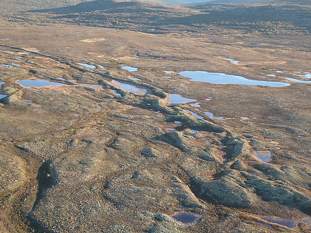
[[File:Billudden1.JPG|thumb|Aerial view of a partially drowned esker at [[Billudden]] in northern [[Uppland]], Sweden. The shape is modified by coastal processes.]]
An '''esker''', '''eskar''', '''eschar''', or '''os''', sometimes called an ''asar'', ''osar'', or ''serpent kame'',<ref>[http://www.collinsdictionary.com/dictionary/english/eskar Collins English Dictionary]</ref><ref>{{Cite web |url=http://encyclopedia2.thefreedictionary.com/esker |title=McGraw-Hill Dictionary of Scientific & Technical Terms |access-date=2015-06-30 |archive-url=https://web.archive.org/web/20150420032852/http://encyclopedia2.thefreedictionary.com/Esker |archive-date=2015-04-20 |url-status=dead }}</ref> is a long, winding [[ridge]] of [[stratum|stratified]] [[sand]] and [[gravel]], examples of which occur in [[glacier|glaciated]] and formerly glaciated regions of Europe and North America. Eskers are frequently several kilometres long and, because of their uniform shape, look like [[railway]] [[Embankment (transportation)|embankment]]s.<ref>{{cite web|last=Gedney|first=Larry|title=Eskers: The Upside-Down Riverbeds|url=http://www2.gi.alaska.edu/ScienceForum/ASF6/674.html|work=Alaska Science Forum Article #674|accessdateaccess-date=29 September 2011|date=August 1, 1984|url-status=dead|archive-url=https://web.archive.org/web/20120404024221/http://www2.gi.alaska.edu/ScienceForum/ASF6/674.html|archive-date=4 April 2012}}</ref>
==Etymology==
[[File:Denaliesker.JPG|thumb|Portions of the [[Denali Highway]] in [[Alaska]] are built on eskers.]]
The term ''esker'' is derived from the [[Irish language|Irish]] word ''{{Lang|ga|eiscir''}} ([[Old Irish]]: ''{{Lang-sga|escir''}}), which means "ridge or elevation, especially one separating two plains or depressed surfaces".<ref>{{cite book
| last =Quin
| first =E. G. (gen. ed.)
Line 18:
| location =Dublin
| pages =281
| isbn = 0-901714-29-1 }}</ref> The Irish word was and is used particularly to describe long sinuous ridges, which are now known to be deposits of [[fluvio-glacial]] material. The best-known example of such an ''eiscir'' is the ''[[Esker Riada|Eiscir Riada]]'', which runs nearly the whole width of [[Ireland]] from [[Dublin]] to [[Galway]], a distance of {{convert|200 |km|mi|abbr=on}}, and is still closely followed by the main Dublin-GalwayDublin–Galway road▼
| isbn = 0-901714-29-1 }}</ref>
▲The Irish word was and is used particularly to describe long sinuous ridges, which are now known to be deposits of [[fluvio-glacial]] material. The best-known example of such an ''eiscir'' is the ''[[Esker Riada|Eiscir Riada]]'', which runs nearly the whole width of [[Ireland]] from [[Dublin]] to [[Galway]], a distance of 200 km, and is still closely followed by the main Dublin-Galway road
The synonym ''os'' comes from the Swedish word for an esker{{Lang|sv|ås}}, ''ås''"ridge".
==Geology==
Most eskers are argued to have formed within ice-walled tunnels by streams that flowed within and under glaciers. They tended to form around the time of the [[glacial maximum]], when the glacier was slow and sluggish. After the retaining ice walls melted away, stream deposits remained as long winding ridges. Water can flow uphill if it is under pressure in an enclosed pipe, such as a natural tunnel in ice.
Eskers may also form above glaciers by accumulation of sediment in [[Jökulhlaup#Supraglacial and subglacial water flow|supraglacial channels]], in [[crevasse]]s, in linear zones between stagnant blocks, or in narrow embayments at glacier margins. Eskers form near the terminal zone of glaciers, where the ice is not moving as fast and is relatively thin.<ref name=Easterbrook>{{cite book
Line 37 ⟶ 36:
[[File:Esker-PB110050.JPG|thumb|Esker in [[Sims Corner Eskers and Kames]] National Natural Landmark, Washington, US. (Trees at the edge of the esker and the single lane road crossing the esker to the right of the photo provide scale.)]]
Plastic flow and melting of the basal ice determines the size and shape of the subglacial tunnel. This in turn determines the shape, composition and structure of an esker. Eskers may exist as a single channel, or may be part of a branching system with [[tributary]] eskers. They are not often found as continuous ridges, but have gaps that separate the winding segments. The ridge crests of eskers are not usually level for very long, and are generally knobby. Eskers may be broad-crested or sharp-crested with steep sides.<ref name=Easterbrook/> They can reach hundreds of kilometers in length and are generally 20–30 metres{{convert|20|–|30|m|ft|abbr=on}} in height.
The path of an esker is governed by its water pressure in relation to the overlying ice. Generally, the pressure of the ice was at such a point that it would allow eskers to run in the direction of glacial flow, but force them into the lowest possible points such as valleys or river beds, which may deviate from the direct path of the glacier. This process is what produces the wide eskers upon which roads and highways can be built. Less pressure, occurring in areas closer to the [[glacial maximum]], can cause ice to melt over the stream flow and create steep-walled, sharply-arched tunnels.<ref>Shreve, R.L., 1985, Esker characteristics in terms of glacier physics, Katahdin esker system, Maine: GSA Bulletin, v. 96, pp. 639–646.</ref>
Line 53 ⟶ 52:
| chapter= Accumulation
| pages =207–208
}}</ref> These dunes are often found in the leeward side of eskers, if the esker is not oriented parallel to prevailing winds.<ref name=Sepp2004/> Examples of dunes developed on eskers can be found in both [[Lapland (Finland)|Swedish]] and [[Lapland (Finland)|Finnish]] [[Sápmi|Lapland]].<ref name=Sepp2004/><ref>{{cite journal |last=Seppälä |first=Matti |author-link=Matti Seppälä |date=1972 |title=Location, morphology and orientation of inland dunes in northern Sweden |journal=[[Geografiska Annaler|Geografiska Annaler.: Series A, Physical Geography]] |volume=54 |issue=2 |pages=85–104 |doi= 10.1080/04353676.1972.11879860}}</ref>
Lakes may form within depressions in eskers. These lakes can lack surface outflows and inflows and have drastic fluctuations over time.<ref>{{Cite book|title=Källor i Sverige|last=Källakademin|publisher=Svensk Byggtjänst|year=2006|isbn=91-7333-104-X|location=Sundbyberg|pages=196|language=Swedish}}</ref>
==Life on eskers==
Eskers are critical to the ecology of Northern Canada. Several plants that grow on eskers, including [[bear root]] and [[cranberries]], are important food for bears[[bear]]s and migrating waterfowl; animals from [[grizzly bearsbear]]s to [[Tundra wolf|tundra wolves]] to [[ground squirrelssquirrel]]s can burrow into the eskers to survive the long winters.<ref>''National Geographic Almanac of Geography'', 2005, p. 155, {{ISBN|0-7922-3877-X}}</ref>
==Examples of eskers==
Line 63 ⟶ 64:
===Europe===
In [[Sweden]], [[Uppsalaåsen]] stretches for {{convert|250|km|mi|abbr=on}} and passes through [[Uppsala]] city. The [[Badelundaåsen]] esker runs for over {{convert|300|km|mi|abbr=on}} from [[Nyköping]] to lake [[Siljan_Siljan (lake)|Siljan]]. [[Pispala]]'s [[Pyynikki Esker]] in [[Tampere]], Finland, is on an esker between two lakes carved by [[glacier]]s. A similar site is [[Punkaharju]] in [[Finnish Lakeland]].
[[Pispala]] in [[Tampere]], [[Finland]] is on an esker between two lakes carved by [[glacier]]s. A similar site is [[Punkaharju]] in [[Finnish Lakeland]].
The village of [[Kemnay, Aberdeenshire|Kemnay]] in Aberdeenshire, Scotland has a {{convert|5 |km|mi|abbr=on}} esker locally called the Kemb Hills. In [[Berwickshire]] in southeast Scotland is Bedshiel Kaims, a 3km {{convert|3|km|mi|abbr=on|adj=mid|-long}} example which is up to 15m{{convert|15|m|ft|abbr=on}} high and is a legacy of an ice-stream within the [[Tweed Valley]].<ref>{{cite book |last1=Stone |first1=P. |title=South of Scotland (British Regional Geology) |date=2012 |publisher=British Geological Survey |isbn=978-085272-694-5 |pages=191–92 |edition=Fourth}}</ref>
===North America===
[[Great Esker Park]] runs along the Back River in [[Weymouth, Massachusetts]], and is home to the highest esker in North America ({{convert|90 |ft|m|abbr=on|order=flip}}).<ref>{{citationCite web needed|date=January2017-04-25 2013|title=Mountain And Glacial Landforms: What Is An Esker? |url=https://www.worldatlas.com/articles/mountain-and-glacial-landforms-what-is-an-esker.html |access-date=2022-07-13 |website=WorldAtlas |language=en-US}}</ref>
There are over 1,000 eskers in the [[U.S. state|state]] of [[Michigan]], primarily in the south-central [[Lower Peninsula]]. The longest esker in Michigan is the {{convert|22 mile |mi|km|abbr=on|order=flip|adj=mid|-long}} ''Mason Esker'', which stretches south-southeast from [[DeWitt, Michigan|DeWitt]] through [[Lansing, Michigan|Lansing]] and [[Holt, Michigan|Holt]], before ending near [[Mason, Michigan|Mason]].<ref>{{cite web |url=http://web2.geo.msu.edu/geogmich/eskers.html |title=Archived copyEskers |accessdateaccess-date=2013-12-02 |url-status=dead |archive-url=https://web.archive.org/web/20131203084415/http://web2.geo.msu.edu/geogmich/eskers.html |archive-date=2013-12-03 }}</ref>
Esker systems in the U.S. state of Maine can be traced for up to {{convert|100 miles|mi|km|abbr=on|order=flip}}.<ref name="MaineEskers">{{cite web | [httpurl=https://www.maine.gov/doc/nrimcdacf/mgs/explore/surficial/facts/surficial.htm] | title=Surficial Geologic History of Maine | publisher=Maine Geological Survey | work=Explore Maine Geology | date=6 October 2005 | accessdate=30 August 2022}}</ref>
The Thelon Esker runsis foralmost {{convert|800|km|mi|abbr=on}} kilometerslong, (497straddling miles)the andboundary straddlesbetween the borderterritories betweenof [[Northwest TerritoriesNunavut]] and [[NunavutNorthwest Territories]] in [[Canada]].<ref>{{cite book|last=Gray|first=Charlotte|title=The Museum Called Canada: 25 Rooms of Wonder|year=2004|publisher=Random House|isbn=0-679-31220-X|url-access=registration|url=https://archive.org/details/museumcalledcana00gray|page=56}}</ref>
[[Uvayuq]] or Mount Pelly, in [[Ovayok Territorial Park]], the Kitikmeot Region, [[Nunavut]] is an esker.
Roads are sometimes built along eskers to save expense. Examples include the [[Denali Highway]] in [[Alaska]], the [[Route Transtaïga|Trans-Taiga Road]] in [[Quebec]], and the "Airline" segment of [[Maine State Route 9]] between [[Bangor, Maine|Bangor]] and [[Calais, Maine|Calais]].<ref>[https://web.archive.org/web/20080113053203/http://www.downeastregion.com/way_downeast.php Down East Region]</ref> There are numerous long eskers in the [[Adirondack State Park]] in upstate [[New York (state)|New York]].
There are numerous long eskers in the [[Adirondack State Park]] in upstate [[New York (state)|New York]]. The [[Rainbow Lake (New York)|Rainbow Lake]] esker bisects the eponymous lake and extends discontinuously for 85 miles (c. 137 km). Another long discontinuous esker extends from Mountain Pond through [[Keese Mill, New York|Keese Mill]], passing between [[Upper St. Regis Lake]] and the Spectacle Ponds, and continuing to Ochre, Fish, and Lydia Ponds in the [[Saint Regis Canoe Area|St. Regis Canoe Area]]. A 150-foot-high esker bisects the [[Five Ponds Wilderness Area]].<ref>{{Cite web|title = Sea Serpents in the Adirondacks? You Bet! |url = http://www.adirondackalmanack.com/2009/11/sea-serpents-in-the-adirondacks-you-bet.html|access-date = 2015-07-30|work=Adirondack Almanack| date=7 November 2009 }}</ref>
==See also==
* {{annotated link|TunnelEskers valleyProvincial Park}}
* {{annotated link|Glacial landform}}
* {{annotated link|Glacier morphology}}
* {{annotated link|Eskers Provincial ParkKame}} (British Columbia, Canada)
* {{annotated link|Tunnel valley}}
==References==
{{reflist|colwidth=30em}}▼
==Further reading==
* {{cite book
| last = Trenhaile
Line 99 ⟶ 104:
| isbn = 978-0-19-542474-4
}}
▲{{reflist|colwidth=30em}}
==External links==
Line 106 ⟶ 109:
* [https://web.archive.org/web/20070607011324/http://www.maine.gov/doc/nrimc/mgs/explore/surficial/facts/surf-10.htm Oblique aerial photo of an esker in Waterford, Maine]
* [http://homepage.eircom.net/~williamfinnerty/chaplefinnerty/esker/riada1.htm Esker Riada Webpage]
* Diagram illustrating (i) tunnel in glacier before retreat of ice, forming (ii) meandering esker in [https://web.archive.org/web/20070711041432/http://www.dcnr.state.pa.us/topogeo/education/es6/es6.pdf ''The Ice Melts: Deposition''], p. 6 of "Pennsylvania and the Ice Age" published 1999 by PA DCNR [https://web.archive.org/web/20160304002357/http://www.dcnr.state.pa.us/topogo Bureau of Topographic and Geologic Survey]
* [https://web.archive.org/web/20081204092736/http://www.bridgenorthesker.ca/ The Bridgenorth Esker: geomorphology and sedimentology]