Modjeska Peak: Difference between revisions - Wikipedia
 Article Images
Content deleted Content added
m |
|||
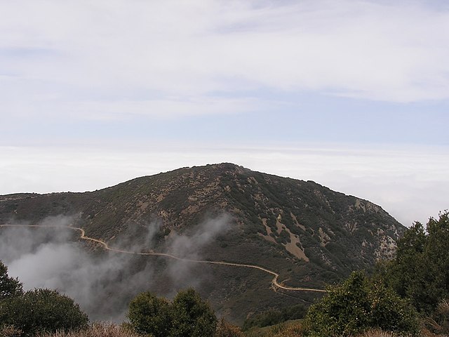
Line 1: {{Short description|Peak in the Santa Ana mountain range}} {{Use mdy dates|date=September 2024}} {{Infobox mountain | name = Modjeska Peak Line 5 ⟶ 6: | photo_caption = Modjeska Peak as seen from nearby [[Santiago Peak]] | elevation_ft = 5499 | elevation_ref = {{NAVD88}}<ref name="pb">{{cite peakbagger |pid=1435 |name=Modjeska Peak, California |accessdate=August 5, 2009 | prominence_ft = 536 | prominence_ref = <ref name="pb"/> Line 16 ⟶ 17: | coordinates = {{coord|33.7197414|N|117.5450468|W|type:mountain_region:US-CA_scale:100000_source:GNIS|format=dms|display=inline,title}} | range_coordinates = | coordinates_ref = <ref name="gnis">{{cite gnis |id=246049 |name=Modjeska Peak |accessdate=August 5, 2009 | topo = [[United States Geological Survey|USGS]] Santiago Peak | first_ascent = Line 27 ⟶ 28: ==History== The peak, which was formerly unnamed and generally lumped in with Santiago Peak, was dubbed Modjeska Peak following the death of Helena Modjeska. The [[Ebell Society]] of Santa Ana campaigned in June 1909 for the new name to honor Modjeska and the change was made sometime thereafter.<ref>{{cite news |title=Club Notes |url=https://www.newspapers.com/image/47145131/ |access-date= Aside from [[United States Forest Service]] rangers, the first recorded people to hike the new trail from Modjeska Canyon to Modjeska Peak were J. H. Scott and A. J. Perkins in April 1919.<ref>{{cite news |title=Santa Anans are First Hikers Over New Trail to Peak |url=https://www.newspapers.com/image/71486732/ |access-date= The Coors American Original 150, a 150-mile (240 km) [[mountain biking]] race from [[Palm Springs, California|Palm Springs]] to [[Newport Beach, California|Newport Beach]], traversed Modjeska Peak as one of the two mountain ranges included in the race's course. The race took place on October 2, 1988.<ref>{{cite news |title=Tustin Honda Among Bike Race Sponsors |url=https://www.newspapers.com/image/123148316/ |access-date= Modjeska Peak formerly had radio and television infrastructure in place. In 1996, [[Pacific Bell]] began providing a [[Multichannel Multipoint Distribution Service]] ("wireless cable") television service in Southern California with its tower atop Modjeska Peak being one of the two broadcast sources.<ref>{{cite news |last1=Miller |first1=Greg |title=Cable TV, Unplugged - Pacific Bell Readies O.C. Wireless System |url=https://www.newspapers.com/image/159371380/ |access-date= ===Wildfires and incidents=== Modjeska Peak was burned in a 1926 wildfire that began in Santiago Canyon on October 31.<ref name="sa1">{{cite news |title=Snow 6 Inches Deep Recorded in Silverado |url=https://www.newspapers.com/image/74405318/ |access-date= On March 26, 1972, a [[Cessna 172|Cessna 172H]] with one pilot and two passengers on board slammed into the side of Modjeska Peak, killing two. The plane originated from [[Las Vegas]] and was en route to [[Hawthorne Municipal Airport (California)|Hawthorne Municipal Airport]] in the Los Angeles area. Since the plane crashed at night, the wreckage was not discovered until 15 hours later when a [[United States Marine Corps]] helicopter was flying over the area for training. The lone survivor of the crash was described as being in "satisfactory" condition and was only admitted to the hospital for observation.<ref>{{cite news |title=2 Die, 1 Survives in Light Plane Crash on Modjeska Peak |url=https://www.newspapers.com/image/385434731/ |access-date= In late November 1980, a fire called the Indian Canyon Fire was started by an [[arson]]ist. It burned {{convert|28000|acre}} and reached the northwest corner of Modjeska Peak.<ref>{{cite news |last1=Hicks |first1=Jerry |title=Indian Canyon Fire - Restoring Burned Area is Next Step |url=https://www.newspapers.com/image/387152138/ |access-date= On December 27, 1999, a vehicle driving near the top of Modjeska Peak veered off the trail and crashed, leaving the motorist uninjured but starting a small brush fire. The fire was quickly extinguished.<ref>{{cite news |title=Motorist Unhurt After Car Tumbles |url=https://www.newspapers.com/image/579855520/ |access-date= The 2007 [[Santiago Fire]] burned through Modjeska Peak.<ref>{{cite news |last1=Barboza |first1=Tony |author2=Janet Wilson |author3=Seema Mehta |title=Fire Crews Catch a Break From the Weather, For Now |url=https://www.newspapers.com/image/193625795/ |access-date= ==References== | |||