File history
Click on a date/time to view the file as it appeared at that time.
| Date/Time | Thumbnail | Dimensions | User | Comment | |
|---|---|---|---|---|---|
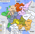
| current | 01:39, 17 June 2006 |  | 610 × 599 (321 KB) | ~Pyb | en:User:Silverhelm is the author of this image file. Its contents are based in part on a map published in the "Historical Atlas" by Prof. William R Shepherd, pub. Henry Holt & Co. (New York, 1911). Category:Maps of the Holy Roman Empire |
File usage
The following pages on the English Wikipedia use this file (pages on other projects are not listed):
Global file usage
This file contains additional information, probably added from the digital camera or scanner used to create or digitize it.
If the file has been modified from its original state, some details may not fully reflect the modified file.
| Author |
|
|---|---|
| Copyright holder |
|
| Short title |
|
| Horizontal resolution | 28.34 dpc |
| Vertical resolution | 28.34 dpc |
 Article Images