File:Western Sahara Topography.png - Wikipedia
 Article Images

Original file (1,318 × 1,183 pixels, file size: 1.05 MB, MIME type: image/png)
File history
Click on a date/time to view the file as it appeared at that time.
| Date/Time | Thumbnail | Dimensions | User | Comment | |
|---|---|---|---|---|---|
| current | 21:23, 29 June 2007 | | 1,318 × 1,183 (1.05 MB) | Sadalmelik | Better data, better colours |
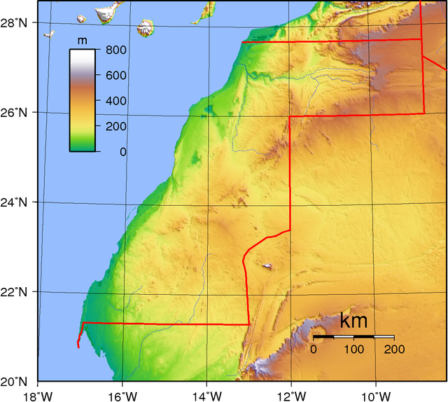
| 17:02, 22 June 2007 |  | 1,318 × 1,183 (885 KB) | Sadalmelik | {{Information |Description=Topographic map of Western Sahara. Created with GMT from GLOBE data, |Source=self-made |Date=June 22, 2007 |Author= Sadalmelik }} Category:Maps of Western Sahara Category:Topographic maps of Africa |
File usage
The following 6 pages use this file:
Global file usage
The following other wikis use this file:
- Usage on af.wikipedia.org
- Usage on ar.wikipedia.org
- Usage on bar.wikipedia.org
- Usage on da.wikipedia.org
- Usage on es.wikipedia.org
- Usage on fr.wikipedia.org
- Usage on hu.wikipedia.org
- Usage on ja.wikipedia.org
- Usage on lt.wikipedia.org
- Usage on pl.wikipedia.org
- Usage on ru.wikipedia.org
- Usage on th.wikipedia.org
- Usage on uk.wikipedia.org
- Usage on vec.wikipedia.org
- Usage on zgh.wikipedia.org