Portal:Ancient Egypt/Selected picture - Wikipedia
Selected pictures
Map of the Giza pyramid complex, located 20 km (12.5 mi) southwest of Cairo, Egypt. This Ancient Egyptian necropolis consists of the Great Pyramid, the Pyramid of Khafre, and the Pyramid of Menkaure, along with a number of smaller satellite edifices, known as "queens" pyramids, causeways and valley pyramids, and most noticeably the Great Sphinx. The site has attracted visitors and tourists since classical antiquity, when these Old Kingdom monuments were already over 2,000 years old.
In antiquity, Ancient Egypt was divided into two lands: Upper Egypt and Lower Egypt. To the south, it was bounded by the land of Kush, and to the East, the levant. Surrounded by harsh deserts, the river Nile was the lifeline of this ancient civilization.
The Rosetta Stone is a fragment of a granite stele containing a decree written in Hieroglyphs, Demotic, and Greek. Discovered in 1799, the stone contributed greatly to the process of hieroglyph decipherment.
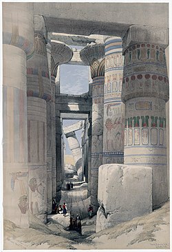
Credit: David Roberts RA, artist and Haghe, Louis, 1806-1885, lithographer
Karnak: "Dromos or first court of the temple" colored lithograph of Karnak.
The pyramids of Giza are among the most recognizable symbols of the civilization of ancient Egypt.


