Quebec Route 205
Contributors to Wikimedia projects
 Article Images
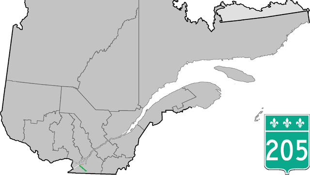
Route 205 is a two-lane north/south highway on the south shore of the Saint Lawrence River in the Montérégie region of Quebec, Canada. Its northern terminus is in Beauharnois at the junction of Route 132 and the southern terminus is at the junction of Route 219, in Hemmingford Township.
Route 205 | ||||
|---|---|---|---|---|
 | ||||
| Route information | ||||
| Maintained by Transports Québec | ||||
| Length | 36 km[1] (22 mi) | |||
| Major junctions | ||||
| South end | ||||
| North end | ||||
| Location | ||||
| Country | Canada | |||
| Province | Quebec | |||
| Highway system | ||||
| ||||

Municipalities along Route 205
-
Approaching Route 205 and Autoroute 30 interchange in Beauharnois.
Major intersections
This article contains a bulleted list or table of intersections which should be presented in a properly formatted junction table. Please consult this guideline for information on how to create one. Please improve this article if you can. (November 2021)
| RCM or ET | Municipality | Km | Junction | Notes |
|---|---|---|---|---|
Southern terminus of Route 205 | ||||
| Les Jardins-de-Napierville | Hemmingford | 0.0 | R-219 | 219 SOUTH: to Hemmingford Village 219 NORTH: to Saint-Patrice-de-Sherrington |
| Sainte-Clotilde | 15.3 | R-209 | 209 SOUTH: to Saint-Chrysostome 209 NORTH: to Saint-Rémi | |
| Beauharnois-Salaberry | Saint-Urbain-Premier | 21.2 | R-207 (South end) | 207 NORTH: to Saint-Isidore |
| Sainte-Martine | 28.0 29.1 |
R-138 (Overlap 1.1 km) | 138 WEST: to Ormstown 138 EAST: to Mercier | |
| Beauharnois | A-30 | 30 WEST: to Salaberry-de-Valleyfield 30 EAST: to Chateauguay | ||
| 38.8 38.9 |
R-132 | 132 WEST: to Salaberry-de-Valleyfield 132 EAST: to Léry | ||
Northern terminus of Route 205 | ||||
See also
References
- ^ Ministère des transports, "Distances routières", page 80, Les Publications du Québec, 2005
External links
- Provincial Route Map (Courtesy of the Quebec Ministry of Transportation) (in French)
- Route 205 in Google Maps
This Quebec road, road transport or highway-related article is a stub. You can help Wikipedia by expanding it. |