Wikipedia:WikiProject UK geography - Wikipedia


| UK geography articles by quality and importance | |||||||
|---|---|---|---|---|---|---|---|
| Quality | Importance | ||||||
| Top | High | Mid | Low | NA | ??? | Total | |
| 5 | 21 | 23 | 49 | ||||
| 1 | 13 | 15 | 29 | ||||
| 3 | 27 | 127 | 117 | 274 | |||
| B | 12 | 100 | 280 | 448 | 68 | 908 | |
| C | 5 | 111 | 488 | 1,657 | 132 | 2,393 | |
| Start | 1 | 85 | 1,050 | 8,621 | 135 | 9,892 | |
| Stub | 56 | 11,228 | 152 | 11,436 | |||
| List | 2 | 23 | 144 | 509 | 11 | 689 | |
| Category | 4,062 | 4,062 | |||||
| Disambig | 2 | 31 | 33 | ||||
| File | 66 | 66 | |||||
| Portal | 1 | 1 | |||||
| Project | 4 | 4 | |||||
| Template | 236 | 236 | |||||
| NA | 4 | 22 | 447 | 482 | 955 | ||
| Other | 1 | 1 | |||||
| Assessed | 23 | 356 | 2,201 | 23,067 | 4,883 | 498 | 31,028 |
| Total | 23 | 356 | 2,201 | 23,067 | 4,883 | 498 | 31,028 |
| WikiWork factors (?) | ω = 130,855 | Ω = 5.25 | |||||
- Wikipedia:WikiProject British and Irish hills
- Wikipedia:WikiProject UK Railways
- Wikipedia:WikiProject UK Roads
- Wikipedia:WikiProject UK Trams
- Wikipedia:WikiProject UK Waterways
- Wikipedia:WikiProject England
- Wikipedia:WikiProject Bedfordshire (inactive)
- Wikipedia:WikiProject Berkshire
- Wikipedia:WikiProject Buckinghamshire (inactive)
- Wikipedia:WikiProject Bristol
- Wikipedia:WikiProject Cambridge (redirected to WikiProject East Anglia)
- Wikipedia:WikiProject Cheshire
- Wikipedia:WikiProject Cornwall
- Wikipedia:WikiProject Derbyshire
- Wikipedia:WikiProject Devon
- Wikipedia:WikiProject Dorset
- Wikipedia:WikiProject East Anglia
- Wikipedia:WikiProject Essex (task force)
- Wikipedia:WikiProject Gloucestershire
- Wikipedia:WikiProject Greater Manchester
- Wikipedia:WikiProject Hampshire (inactive)
- Wikipedia:WikiProject Herefordshire
- Wikipedia:WikiProject Hertfordshire (inactive)
- Wikipedia:WikiProject Kent
- Wikipedia:WikiProject Lancashire and Cumbria
- Wikipedia:WikiProject Lincolnshire
- Wikipedia:WikiProject Stamford (defunct)
- Wikipedia:WikiProject London
- Wikipedia:WikiProject Merseyside
- Wikipedia:WikiProject North East England
- Wikipedia:WikiProject Northamptonshire
- Wikipedia:WikiProject Nottinghamshire
- Wikipedia:WikiProject Shropshire
- Wikipedia:WikiProject Somerset
- Wikipedia:WikiProject Surrey
- Wikipedia:WikiProject Sussex
- Wikipedia:WikiProject Warwickshire
- Wikipedia:WikiProject West Midlands
- Wikipedia:WikiProject Coventry (inactive)
- Wikipedia:WikiProject Wight
- Wikipedia:WikiProject Wiltshire
- Wikipedia:WikiProject Worcestershire
- Wikipedia:WikiProject Yorkshire
- Wikipedia:WikiProject Wales
- Wikipedia:WikiProject Scotland
- Wikipedia:WikiProject Northern Ireland
...on Wikipedia, the free encyclopedia that anyone can edit.
- Portal: Portal:United Kingdom
- Mother projects: WikiProject United Kingdom • WikiProject Countries
- Sister project: WikiProject Cities
- Related projects: WikiProject England • WikiProject Scotland • WikiProject Wales • WikiProject Northern Ireland
(and many sub-projects, see list on right)
Welcome to the United Kingdom Geography WikiProject. We are a user group dedicated to improving and expanding Wikipedia's coverage of articles related to the Geography of the United Kingdom.
Although our remit is broad, extending from the climate to infrastructure through to the geology and local government in the United Kingdom, we are most closely involved with facilitating the development of Britain's settlements and divisions of land, and ensuring a consistent approach is taken across the United Kingdom's geography class articles.
WikiProject UK Geography is the mother WikiProject of many British local Wikiprojects, and thus is here to co-ordinate and centralise the sharing of ideas and guidelines, developing writing standards, infoboxes, and other data presentation formats, and for setting up collaborations with the goal of reaching featured status for important UK places and geographical articles. Don't be put off by the word "geography", it just means writing about your local area!
News
Today's featured articles
- 05 Oct 2024 – River Parrett (talk · edit · hist) will be Today's Featured Article; see blurb
Proposed deletions
- 22 Sep 2024 – Knapps Brook (talk · edit · hist) PRODed by Russss (t · c) was redirected to Houghton Brook (talk · edit · hist)
Categories for discussion
- 21 Sep 2024 – Category:Southend-on-Sea (district) (talk · edit · hist) was CfDed by Davidstewartharvey (t · c); see discussion
Good article nominees
Good article reassessments
- 01 Oct 2024 – Kingston upon Hull (talk · edit · hist) was nominated for GA reassessment by Theleekycauldron (t · c); see discussion
Requested moves
- 30 Sep 2024 – Walton-on-the-Hill (talk · edit · hist) is requested to be moved to Walton-on-the-Hill, Surrey by Crouch, Swale (t · c); see discussion
Articles to be merged
- 30 Sep 2024 – Benover (talk · edit · hist) is proposed for merging to Benover by Crookesmoor (t · c); see discussion
- 08 May 2024 – Abbey Mill, Reading (talk · edit · hist) is proposed for merging to Reading Abbey by Tim Landy (t · c); see discussion
Articles to be split
- 06 Jan 2024 – West Lothian (talk · edit · hist) is proposed for splitting by Crowsus (t · c); see discussion
- 06 Jan 2024 – Midlothian (talk · edit · hist) is proposed for splitting by Crowsus (t · c); see discussion
- 25 Sep 2021 – Totton and Eling (talk · edit · hist) is proposed for splitting by Crouch, Swale (t · c); see discussion
A list of articles needing cleanup associated with this project is available. See also the tool's wiki page and the index of WikiProjects.
Project watchlist
 Aims
Aims
Many of WikiProject UK Geography's daughter projects have identified their own objectives and key articles to develop towards the featured article standard, which this project wholly supports and encourages. However, this project also aims to facilitate the development of a number of key articles related to the overall geography of the United Kingdom:
Short term
- Our aims in the short term, are to achieve the following:
- Bring United Kingdom up to featured article standard.
- Bring each of the cities of the United Kingdom up to good article standard.
- Improve systems of communication between this project and its daughter projects.
Mid term
- Our mid-term aims for the project are:
- Bring each of the British capitals of London, Edinburgh, Cardiff and Belfast up to featured article standard.
- Have ten articles at a county or district level up to featured article standard.
- Develop a series of professional, inclusive and wide-ranging guidelines related to the writing and presentation of articles related to Britain's geography.
Long term
- Our long term aims for the project are:
- Improving all Wikipedia articles that are concerned with the geography of the United Kingdom, including its history, geography, people, constructions and buildings, etc. etc.
- All relevant articles should be included in the Category:United Kingdom or one of its subcategories.
- Articles on all UK subdivisions, settlements, and other notable geographical features.
To-do list
To add this to-do list to your userpage use: {{Wikipedia:WikiProject_UK_geography/todo}}
Guidelines
Guidelines at WikiProject UK Geography are a key element of how the project operates; they ensure that the UK's articles have a consistent House Style and provide a lasting consistency for our readers to benefit from. Working in partnership with "international" WikiProjects, UK Geography has developed the following Project guidelines which indicate standardised, consensual recommended approaches when writing about certain aspects of Britain's geography. They each include tips on obtaining the highest of awards for articles:
- /How to write about settlements - the most common one you need!
- /How to write about counties
- /How to write about districts
- /How to write about territorial geographies - constituencies, local government districts, postal and using statistics about them
- /How to write about London stations (good starting point for stations in general)
- /How to write about rivers
- /How to write about UK postal administration
- /How to write about UK Waterways
Embedded Audio Pronunciations
A new sub-project has been set up to complement the work done within WP:UKGEO. Wikipedia:WikiProject UK geography/Embedded Audio Pronunciations seeks to provide a comprehensive, high-quality range of audio files consisting of native British English pronunciations of relevant words and names: counties, settlements, rivers, mountains and so on. Ideally, both "Received Pronunciation" and local accent variations would be provided, and a repository of public-domain or GFDL-licensed files built up for the benefit of anybody interested in the UK and the English language. In particular, every file provided would ideally be linked to the relevant Wikipedia article. More information and guidelines are provided at this page.
Templates
- For templates used for the administration and organisation of the Project and its remit, see Wikipedia:WikiProject UK geography/Templates.
Assessment and progress of articles
On the right of this page is a bot-generated table of the assessment process of WikiProject UK geography supported articles. The stats are generated automatically daily, but they can be updated manually by entering UK geography (and replacing Foobar) into the Category box here.
The project has categorised articles according to the WP 1.0 criteria:
- Featured Articles: need little or no work.
- 'A' class: need a very small amount of work, followed by FA nomination.
- Good Articles: a little more work required.
- 'B' class: getting there - overall structure in place, but more work needed on the detail, more references etc
- 'C' class: starting to come together but may still lack a major section, significant referencing etc
- Start class: short, lacks details, key facts, illustration, etc.
- Stub class: very short, lacking important details.
- There is a list of very short "stub" articles here.
- Main tool page: toolserver.org
- Reflinks - Edits bare references - adds title/dates etc. to bare references
- Checklinks - Edit and repair external links
- Dab solver - Quickly resolve ambiguous links.
- Peer reviewer - Provides hints and suggestion to improving articles.


Resources
![]()
Wikimedia Commons has media related to United Kingdom.
- Statistics: Office for National Statistics, Census related resources, Northern Ireland Statistics and Research Agency (NISRA), Neighbourhood statistics (Parish data etc.)
- Population data (see below for England): Ayrshire, East (PDF), Falkirk, Moray, Lanarkshire, North
- 1997-2011 economic data, which includes gross value added (GVA) down to NUTS3 level as well as their industry sectors.
- Church of England Resources, publications, and data including parish-level census and deprivation information.
- Maps:
- Multimap (can't copy)
- Ordnance Survey: OS Get a map (can't copy) | Ordnance Survey OpenData | OS Maps of Scotland (and England) | Ordnance Survey for Northern Ireland (can't copy) | OS (Out of copyright) (open licensed!)
- OpenStreetMap (open licensed!) Community built maps which are incomplete, but good coverage of some areas/cities. See wikiproject
- out of copyright ordnance survey scans. Commercial restriction for direct image copying.
- Ordnance Survey® Election Maps–boundaries of civil parishes, wards, boroughs etc., up to street map scale. The draconian terms and conditions don't seem to prevent GFDL licensing of research by Wikipedia editors, as long as the editors themselves don't use the information for financial gain, and no-one copies actual extracts, mapping data or layers from the maps (so... can't copy)
- Books: There is a list of UK geography books and the Wikipedians who own them at Wikipedia:Library/Places#UK. You can request info from the owners of the relevant books. archive.org texts is a good source for copyright expired material.
- Websites: 1911 Encyclopaedia Britannica [1], Historical Directories A Vision of Britain through Time OpenGeoscience (Geological data) NERC Soil Portal National Heritage Listed Buildings
- Photos
- Geograph British Isles project
- Geolocation.ws - Geotagged creative commons images from Wikimedia Commons, Panoramio, Picasa, Flickr
- Distance : GENUK&I distance gazetteer, Postcode distance calculator
- Archaeology: English Heritage Gateway 49 resources on England's historic sites and buildings. See also: Archaeological Data Services Search
| England | |
|---|---|
| Bedfordshire | Bedfordshire facts & figures |
| · Luton | |
| Berkshire | West Berkshire 2001 Census data |
| Bristol | Ward finder |
| Buckinghamshire | |
| · Milton Keynes | |
| Cambridgeshire | |
| · Peterborough | 2001 Census Profile of Peterborough Cambridgeshire County Council, June 2003 |
| Cheshire | *George Ormerod, The History of the County Palatine and City of Chester, Vol. 1 2 3, (1819) (Historical & census) |
| · Halton | |
| · Warrington | |
| Cornwall | Parish population data |
| · Isles of Scilly | |
| Cumbria | Census 2001 |
| Derbyshire | |
| · Derby | |
| Devon | See the Devon WikiProject list of resources. |
| · Plymouth | |
| · Torbay | |
| Dorset | Parish population data (import should be complete) |
| · Bournemouth | |
| · Poole | |
| County Durham | Durham County Council 2001 Census data |
| · Darlington | |
| · Hartlepool | |
| · Stockton-on-Tees | |
| East Riding of Yorkshire | |
| · Kingston-upon-Hull | |
| East Sussex | |
| · Brighton and Hove | |
| Essex | Epping Forest census data (includes 1961-2001) |
| · Southend-on-Sea | |
| · Thurrock | |
| Gloucestershire | |
| · South Gloucestershire | |
| Greater London | |
| Greater Manchester | |
| Hampshire | 2001 census |
| · Southampton | |
| · Portsmouth | |
| Herefordshire | 2001 census Population and demographics Excel sheet of Parish population histories |
| Hertfordshire | Population and census data |
| Isle of Wight | |
| Kent | 2001 Census Area Profiles |
| · Medway | |
| Lancashire | |
| · Blackburn with Darwen | |
| · Blackpool | |
| Leicestershire | Census 2001 |
| · Leicester | |
| Lincolnshire | Parish population profiles |
| · North Lincolnshire | |
| · North East Lincolnshire | |
| Merseyside | |
| Norfolk | Census population (Excel speadsheet) South Norfolk: parish data and ward data Links to parish websites in Breckland Breckland further data |
| North Yorkshire | |
| · York | |
| · Middlesbrough | |
| · Redcar and Cleveland | |
| · Stockton-on-Tees | |
| · Northamptonshire | |
| Northumberland | Tynedale population data (PDF) |
| Nottinghamshire | |
| · Nottingham | |
| Oxfordshire | |
| Rutland | |
| Shropshire | |
| · Telford and Wrekin | |
| Somerset | Parish population data |
| · Bath and North East Somerset | Census Data |
| · North Somerset | Census Information |
| South Yorkshire | |
| Staffordshire | Local government history |
| · Stoke-on-Trent | |
| Suffolk | |
| Surrey | |
| Tyne and Wear | |
| Warwickshire | |
| West Midlands | |
| West Sussex | Ward profiles |
| West Yorkshire | |
| Wiltshire | Wiltshire Community History from Wiltshire County Council giving brief historical information and references for settlements including old maps and Population by community 1801–2001 census data |
| · Swindon | Population by community 1801–2001 census data at Wiltshire Community History from Wiltshire County Council |
| Worcestershire | |
Participants
| Following a period of low-activity, WikiProject UK Geography is re-recruiting members. If you feel you can contribute to the project, please add your name. |
You don't need to be British to help with this WikiProject. We welcome all registered editors good with layout and prose, and non-British editors who can point out when we've wrongly assumed we don't need to explain or define something for the reader, or failed to properly establish the context of an article.
To add a UK geography userbox to your user page, please add {{User WP UK geo}} to your talk page to generate...
| This user participates in WikiProject UK geography |
- To add your name to the table, please visit the participants page.
Recognised content
| This is a list of recognized content, updated weekly by JL-Bot (talk · contribs) (typically on Saturdays). There is no need to edit the list yourself. If an article is missing from the list, make sure it is tagged (e.g. {{WikiProject UK geography}}) or categorized correctly and wait for the next update. See WP:RECOG for configuration options. |
Featured articles
 Coventry ring road
- Abberton Reservoir
- Altrincham
- Ashton-under-Lyne
- Bath, Somerset
- Blakeney Point
- Bristol
- Brownhills
- Buildings and architecture of Bristol
- Carrington Moss
- Chartwell
- Chat Moss
- Chew Stoke
- Cley Marshes
- Combe Hill, East Sussex
- Covent Garden
- Denbies
- Doom Bar
- Dorset
- Exmoor
- Geography of Ireland
- Holkham National Nature Reserve
- Kennet and Avon Canal
- Keswick, Cumbria
- Knowle West
- Little Thetford
- Manchester Bolton & Bury Canal
- Manchester
- Manchester Ship Canal
- Marshalsea
- Mendip Hills
- RSPB Minsmere
- Navenby
- Neilston
- Northern England
- Pitfour estate
- Radcliffe, Greater Manchester
- River Parrett
- Sale, Greater Manchester
- Shapinsay
- Skegness
- Isle of Skye
- Somerset Levels
- Titchwell Marsh
- Trafford Park
- Trafford
- Warkworth Castle
- Weymouth, Dorset
- Wormshill
Former featured articles
 M62 motorway
- Birchington-on-Sea
- Blyth, Northumberland
- Buckinghamshire
- Chadderton
- Cheadle Hulme
- Chew Valley
- Chew Valley Lake
- City status in the United Kingdom
- East End of London
- Greater Manchester
- Herne Bay
- Historic counties of England
- Local Government Commission for England (1992)
- Moorgate
- National parks of England and Wales
- Oldham
- Peterborough
- Piccadilly Circus
- Isle of Portland
- St Kilda, Scotland
- Shaw and Crompton
- Sheerness
- Sheffield
- Somerset
- Stretford
- Westgate-on-Sea
- Whitstable
Featured lists
- List of castles in Greater Manchester
- List of freshwater islands in Scotland
- List of islands of Scotland
- List of Orkney islands
- List of castles in Cheshire
- List of civil parishes in Somerset
- List of Shetland islands
- List of Sites of Special Scientific Interest in Avon
- List of Sites of Special Scientific Interest in Cleveland
- List of Sites of Special Scientific Interest in Greater London
- List of Sites of Special Scientific Interest in Greater Manchester
- List of Sites of Special Scientific Interest in Hertfordshire
- List of Sites of Special Scientific Interest in Merseyside
- List of Sites of Special Scientific Interest in Somerset
- List of Sites of Special Scientific Interest in Wiltshire
- List of Sites of Special Scientific Interest in the West Midlands
- List of Sites of Special Scientific Interest on the Isle of Wight
- List of birds of Leicestershire and Rutland
- List of hillforts and ancient settlements in Somerset
- List of scheduled monuments in Bath and North East Somerset
- List of scheduled monuments in Mendip
- List of scheduled monuments in North Somerset
- List of scheduled monuments in Sedgemoor
- List of scheduled monuments in South Somerset
- List of scheduled monuments in Taunton Deane
- Scheduled monuments in Greater Manchester
- List of scheduled monuments in West Somerset (A–G)
- List of scheduled monuments in West Somerset (H–Z)
- List of Sites of Special Scientific Interest in East Sussex
Good articles
 A1 in London
- M25 motorway
- A215 road
- M32 motorway
- A4061 road
- A82 road
- Aberdaron
- Aire and Calder Navigation
- Aldermaston
- Ambrosden
- Arbroath
- Isle of Arran
- Ashford, Kent
- Ashtead
- Astley, Greater Manchester
- River Avon, Bristol
- Avon Gorge
- Beacon Park
- Bedford Park, London
- Ben Nevis
- Bentworth
- Berkhamsted
- Binsted
- Blackdown Hills
- Blagdon Lake
- Bolton
- Bond Street
- Bournemouth
- Bradwall
- Bridgewater Canal
- Bridgwater and Taunton Canal
- Bridgwater Bay
- Bridgwater
- Burnham-on-Sea
- Burrow Mump
- Cadbury Castle, Somerset
- Canterbury
- Carlton Hill, Brighton
- Carmarthenshire
- Carr Hill
- Castle Park, Bristol
- Ceredigion
- Chard, Somerset
- Chatteris
- Cheddar Gorge
- Cheddar, Somerset
- Chester Canal
- Chew Magna
- Chiswick
- Chiswick Mall
- Christchurch, Dorset
- Cleadon
- Clevedon
- Climate of south-west England
- Clwyd
- Cranham
- Crawley
- Crewkerne
- Cromwell's Castle
- Crystal Palace, London
- Cullompton
- Deckham
- Deeping Fen
- Deptford
- Derwent Valley Mills
- Didsbury
- Dolebury Warren
- River Don Navigation
- Dorchester, Dorset
- Dorking
- Dubh Artach
- Dunham Massey
- Dunster
- East Kirkton Quarry
- East Worldham
- Eastbourne
- Ebbor Gorge
- Eccles, Greater Manchester
- Eday
- Ely, Cambridgeshire
- Epsom
- Etal Castle
- Faversham
- Federation of Stoke-on-Trent
- Felling, Tyne and Wear
- Flannan Isles
- Flat Holm
- River Frome, Bristol
- Frome
- Geography of Scotland in the Middle Ages
- Geography of Scotland in the early modern era
- Geography of Somerset
- Geography of Wales
- Geology of Scotland
- Geology of Somerset
- Giffnock
- Glastonbury
- Glastonbury Lake Village
- Glenrothes
- Godalming
- Grand Western Canal
- Grantham Canal
- Hale Barns
- Haslemere
- Hebden, North Yorkshire
- Hebrides
- Helvellyn
- Hengistbury Head
- Lists of mountains and hills in the British Isles
- History of Hertfordshire
- History of Bristol
- History of Somerset
- Kingston upon Hull
- River Hull
- Hyde Park, London
- Ickenham
- River Irwell
- Islands of the Forth
- Islands of the Clyde
- Kersal Moor
- Keynsham
- Kidwelly and Llanelly Canal
- Kilham, Northumberland
- Kirkandrews, Dumfries and Galloway
- Kirkcaldy
- Leatherhead
- Leeds Country Way
- County Borough of Leeds
- Leicester Square
- Leigh, Greater Manchester
- Leigh Woods National Nature Reserve
- Letchworth
- Lismore, Scotland
- Llantwit Major
- London
- London Ringways
- Low Fell
- Ludlow Castle
- Lundy
- M54 motorway
- Malvern, Worcestershire
- Manor Farm, Ruislip
- Marsden Rock
- Mayfair
- Medstead
- Middle Level Navigations
- Middlesex
- Middleton, Leeds
- Middlewich
- Midsomer Norton
- Milford Haven
- Milnrow
- Milton Keynes
- Minehead
- Mingulay
- Monifieth
- Montpelier, Brighton
- Morpeth, Northumberland
- Moston Brook
- Nailsea
- Neath and Tennant Canal
- North Circular Road
- North Pier, Blackpool
- Northallerton
- Northern Isles
- Nunney Castle
- Oakhanger, Hampshire
- Old Chiswick
- Old Man of Hoy
- Orkney
- Outer Hebrides
- Oxford Castle
- Oxford Circus
- Oxford Street
- Pail closet
- Papa Stour
- Partington
- Peak District
- Pembrokeshire
- Penmon
- Plymouth
- Poole
- Port Gaverne
- Portishead, Somerset
- Portsmouth
- Poulton-le-Fylde
- Preston By-pass
- Puddletown
- Quantock Hills
- Raasay
- Radstock
- Reading, Berkshire
- Reculver
- Reigate
- Richmond Park
- River Arun
- River Brue
- River Tone
- River Weaver
- Romford
- River Rother, East Sussex
- River Rother, West Sussex
- Round Hill, Brighton
- Royal Albert Dock, Liverpool
- Royton
- Ruislip
- Ruislip Woods
- Rùm
- Runcorn
- City of Salford
- Salford
- Sand Point and Middle Hope
- Scheduled monuments in Somerset
- The Serpentine
- Sheffield
- Shepton Mallet
- Sheriff Hill
- Shetland
- Shimna River
- Sleaford Navigation
- Sleaford
- Smithfield, London
- Snake Pass
- Snowdon
- Soho
- Somerset Coal Canal
- Somerset Coalfield
- Somerton, Somerset
- South Circular Road, London
- Southcote, Berkshire
- Southgate, West Sussex
- St Catherine's Hill, Dorset
- Staffa
- Staines-upon-Thames
- Stainforth and Keadby Canal
- Stane Street
- Steep Holm
- Stokesay Castle
- Strand, London
- Street, Somerset
- Island of Stroma
- Stroudwater Navigation
- Taunton
- The Level, Brighton
- Thorne and Hatfield Moors
- Trafalgar Square
- River Trym
- Tyldesley
- Upminster
- Urmston
- Uxbridge
- Ventnor
- WWT Slimbridge
- Wales
- Warburton, Greater Manchester
- Watchet
- River Welland
- Wellingborough
- Wellington, Somerset
- Wells, Somerset
- Westhay Moor
- Weston-super-Mare
- Weybridge
- Whitburn, Tyne and Wear
- Whitby
- Whitehall
- Whitton Bridge Pasture
- Widnes
- Windy Nook
- Winslade
- River Witham
- Woking
- Worsley
- Yeovil
- Zennor Head
Former good articles
 A500 road
- Askam and Ireleth
- Atherton, Greater Manchester
- Basingstoke
- Belfast
- Birmingham
- Bristol Harbour
- British Isles
- Carnoustie
- Coatbridge
- Cross Fell
- East Riding of Yorkshire
- England
- Evanton
- Geology of Dorset
- Glasgow
- Hampshire
- Ireland
- Kent
- Norfolk
- Northern Ireland
- Rhondda
- Royal Tunbridge Wells
- Isles of Scilly
- Scotland
- Shrewsbury
- Solihull
- South West Coast Path
- Tameside
- Torquay
- United Kingdom
- Wigan
- York
Did you know? articles
 M32 motorway
- Coventry ring road
- A4061 road
- A8(M) motorway (Northern Ireland)
- A82 road
- 2012 Summer Olympics and Paralympics gold post boxes
- 2015–16 Great Britain and Ireland floods
- Aberchalder
- Abram, Greater Manchester
- Acaster South Ings
- Achanalt
- Achany
- Achentoul
- Ackworth, West Yorkshire
- Acton, Cheshire
- Acton Green, London
- Afon Clun
- Archdeacon Newton
- Ardelve
- Ashford, Kent
- Astwell
- Audenshaw
- Avielochan
- Avon Bridge
- Babington, Somerset
- Backmuir Wood
- Badbea
- Barkip
- Barnet Common
- Barnet Gate
- Baughurst
- Bear Road, Brighton
- Bedford Purlieus National Nature Reserve
- Benty Grange
- Bestwood Country Park
- Bideford Bay
- Binsted
- Black Loch (New Cumnock)
- Blackwall Rock
- Boddam, Aberdeenshire
- Bodinnick
- Boneybefore
- Bonnybridge
- Bottom Wood
- River Bourne, Kent
- Braeriach
- Bridgemere
- Bridgwater Bay
- Bridgwater War Memorial
- Brimham Rocks
- Brimscombe and Thrupp
- Brizlincote
- Broadholme
- Brothertoft
- Brown Willy
- Buildings and architecture of Brighton and Hove
- Canford Cliffs
- Carlbury
- City of Carlisle
- Carlton Hill, Brighton
- Carrington Moss
- Cassiobury Park
- Castle Green, London
- Castle Park, Bristol
- List of castles in Greater Manchester
- Charlcombe
- Cheddar Yeo
- Cholmondeston
- Christmas Common
- Cleadon
- Cliffe, Richmondshire
- Climate of Ireland
- Climate of Northern Ireland
- Climate of south-west England
- Cocklakes
- Cookham Bridge
- County Wildlife Site
- Cowleaze Wood
- Cratendune
- Creoch Loch
- Crooked Billet
- Crowcombe
- Culbone
- Delamere Forest
- Denshaw
- Derry Cairngorm
- Derwent Valley Mills
- Devil's Jumps, Churt
- Devon County Council
- Didmarton
- Dode, Kent
- Dollis Valley Greenwalk
- Doom Bar
- Dorchester, Dorset
- Dorking
- Dowlish Wake
- East Smithfield
- East Worldham
- Ebbor Gorge
- Eddington, Kent
- Elm Grove, Brighton
- Embleton Tower
- England–Wales border
- Etal Castle
- Exeter War Memorial
- Extreme points of the United Kingdom
- Forests of Mara and Mondrem
- Forge Wood
- Fortrose Cathedral
- Fountains Fell
- Fowlsheugh
- Gamlingay Cinques
- Ganarew
- Geography of Somerset
- Geology of London
- Geology of Dorset
- Geology of Gloucestershire
- Glastonbury Lake Village
- Glen Shiel
- Godalming
- Great Bolton
- Great Budworth
- Gresham, Norfolk
- Guide to the Lakes
- Handbridge
- Hankelow
- Harpur Hill Quarry
- Hatherton, Cheshire
- Havergate Island
- Hay-a-Park Gravel Pit
- Heathery Burn Cave
- Heathrow (hamlet)
- Hertfordshire puddingstone
- Hewelsfield
- High Coniscliffe
- Highweek
- Horseshoe Bend, Shirehampton
- Humshaugh
- Ickwell
- Jarn Mound
- King's Mill, Castle Donington
- Kirk Deighton SSSI
- Kirkandrews, Dumfries and Galloway
- Kirkleatham
- Lady Isle
- Lancaut
- St Matthew's Church, Langford
- Langrigg
- Lassington Wood
- Laymoor Quag
- List of Orkney islands
- List of castles in Cheshire
- List of Hewitts and Nuttalls in England
- List of scheduled monuments in Cheshire (1066–1539)
- List of settlements in Devon by population
- Listed buildings in Worthing
- Listed buildings in Crawley
- Listed buildings in Eastbourne
- Little Bolton
- Little Cut
- Little Langdale
- Llantwit Major
- Locally listed buildings in Crawley
- Loch o' th' Lowes (New Cumnock)
- Looe Bridge
- Lord's slope
- Low Coniscliffe
- Low Walworth
- Lower Swell
- Lygon Arms
- Macclesfield Forest
- River Malago
- Manor Farm, Ruislip
- Mapperton
- Marbury, Cheshire
- Mardyke (river)
- Marsden Rock
- Marston Bigot
- Medstead
- Merrybent
- Milton Keynes
- Mingulay
- Minshull Vernon
- RSPB Minsmere
- Monkton Deverill
- Montpelier, Brighton
- Morpeth, Northumberland
- Moss Eccles Tarn
- Moston Brook
- Mount Judd (Nuneaton)
- Nettleton Mill
- River Nevis
- New Fancy
- Newlyn Tidal Observatory
- North Berwick Harbour
- St Mary's Church, North Leigh
- North Piddle
- North West Highlands Geopark
- North West Liberties of Londonderry
- Northam Bridge
- Northgate, West Sussex
- Norton Juxta Twycross
- Oakhanger, Hampshire
- Ochil Hills
- Old Whittington
- Oxford Circus
- Oxford Street
- Pail closet
- Pawlett
- Peckforton
- Penhale Sands
- Philipshill Wood
- Piercebridge
- Pierowall
- Pitfour estate
- Plants Brook
- Platt Fields Park
- Polperro
- Poole, Cheshire
- Portbury Ashlands
- Portlethen Moss
- Potter Fell
- Potters Crouch
- Pow of Inchaffray
- Preston By-pass
- Prestonville, Brighton
- Puddletown
- Quarry Moor
- Reigate
- Riccarton, East Ayrshire
- Richmond Park
- Ridley Bottom, Tidenham
- River Darent
- River Jordan, Dorset
- River Orchy
- Roddon
- Romford Garden Suburb
- Rosal, Sutherland
- Round Hill, Brighton
- Round Island Light, Isles of Scilly
- Ruislip Woods
- St. Jude storm
- St Swithun's Way
- Salisbury Cathedral School
- Salt road
- Salwarpe
- Sandyhills
- Scheduled monuments in Somerset
- Scone, Scotland
- Seacliff
- Seething Lane
- Sharpham
- Shit Brook
- Shitterton
- Siddington, Gloucestershire
- Skinnand
- Sleaford
- Smisby
- Snake Pass
- Somerset Coal Canal
- Somerset Coalfield
- Sound, Cheshire
- St Peter ad Vincula, South Newington
- Southgate, West Sussex
- Springfield Park (London)
- St Andrew's Cross, Glasgow
- St Catherine's Hill, Dorset
- Stac an Armin
- Star of Caledonia
- Island of Stroma
- Stroudwater Navigation
- Sydenham Hill Wood
- River Tale
- Temple Bar, London
- Terras Bridge
- The Level, Brighton
- The Riddy
- Tinsley Green
- Trafalgar Square
- Traffic in Towns
- Treak Cliff Cavern
- Ullinish
- Ulnaby
- Up Hatherley
- Loch Vaa
- WWT Slimbridge
- Walworth, County Durham
- Walworth Gate
- Warmingham
- Warren Hill, Bournemouth
- Warton, Fylde
- Watts Park
- Wellesbourne, Brighton
- Wells St Andrew
- Welsh toponymy
- Wentworth Estate
- Werrington, Staffordshire
- West Hoathly
- Westcott Barton
- Wincheap
- Winslade
- Winter flooding of 2013–14 on the Somerset Levels
- Withernsea
- Woking
- Worsley
- Ynysybwl
- Ythan Estuary
- Zennor Head
Featured pictures
-

A591 road, Lake District - June 2009 Edit 1
-
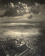
Aerial View of Edinburgh, by Alfred Buckham, from about 1920
-

Canary Wharf from Limehouse London June 2016 HDR
-
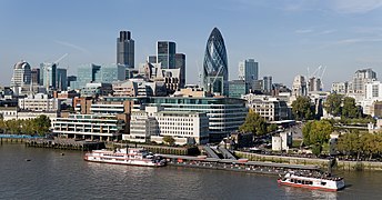
City of London skyline from London City Hall - Oct 2008
-

Lancashire 1610 Speed Hondius - Restoration


Good article nominees
In the News articles
Main page featured articles
- Coventry ring road
- M62 motorway
- Abberton Reservoir
- Altrincham
- Ashton-under-Lyne
- Bath, Somerset
- Birchington-on-Sea
- Blakeney Point
- Bristol
- Brownhills
- Buckinghamshire
- Buildings and architecture of Bristol
- Carrington Moss
- Chadderton
- Chartwell
- Chat Moss
- Cheadle Hulme
- Chew Stoke
- Chew Valley
- Chew Valley Lake
- City status in the United Kingdom
- Cley Marshes
- Combe Hill, East Sussex
- Covent Garden
- Doom Bar
- Dorset
- East End of London
- Exmoor
- Geography of Ireland
- Historic counties of England
- Holkham National Nature Reserve
- Kennet and Avon Canal
- Keswick, Cumbria
- Knowle West
- Little Thetford
- Local Government Commission for England (1992)
- Manchester Bolton & Bury Canal
- Manchester
- Manchester Ship Canal
- Marshalsea
- Mendip Hills
- RSPB Minsmere
- Moorgate
- National parks of England and Wales
- Navenby
- Neilston
- Northern England
- Oldham
- Peterborough
- Piccadilly Circus
- Isle of Portland
- Radcliffe, Greater Manchester
- River Parrett
- St Kilda, Scotland
- Sale, Greater Manchester
- Shapinsay
- Shaw and Crompton
- Sheerness
- Sheffield
- Skegness
- Isle of Skye
- Somerset Levels
- Somerset
- Stretford
- Titchwell Marsh
- Trafford Park
- Trafford
- Warkworth Castle
- Westgate-on-Sea
- Weymouth, Dorset
- Wormshill
Main page featured lists
Picture of the day pictures
-
A591 road, Lake District - June 2009 Edit 1
-
Aerial View of Edinburgh, by Alfred Buckham, from about 1920
-
Canary Wharf from Limehouse London June 2016 HDR
-
City of London skyline from London City Hall - Oct 2008
-
Lancashire 1610 Speed Hondius - Restoration
Former featured topics
Good topics
Featured pictures
Architecture
-

-

-

-

Tower Bridge, by Diliff
-

-

-

Windsor Castle, by Diliff
-

The Gherkin, at 30 St Mary Axe. by Diliff
-

Tower Bridge at Twilight by Diliff
-

-

-
-

London Eye, by Diliff
-
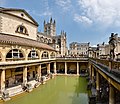
Roman Baths, by Diliff
-


,_corrected_perspective.jpg)


Interiors
-

British Museum Great Court at British Museum, by Andrew Dunn
-

-
-

The Tulip Stair at Queen's House, by Mcginnly


Landscapes
-
-

Sunrise over Stonehenge at Stonehenge by Andrew Dunn
-

-

-

Crazywell cross on Dartmoor, by Herbythyme


Panoramas


Urban
-

Piccadilly Circus, by Chalmers Butterfield
-

Beer Street, by William Hogarth
-

Gin Lane, by William Hogarth


| This is a WikiProject, an area for focused collaboration among Wikipedians. New participants are welcome; please feel free to participate!
|