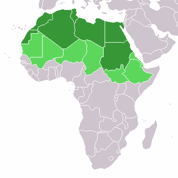
Fájl:LocationNorthernAfrica.png – Wikipédia
 Article Images
Fájltörténet
Kattints egy időpontra, hogy a fájl akkori állapotát láthasd.
| Dátum/idő | Bélyegkép | Felbontás | Feltöltő | Megjegyzés | |
|---|---|---|---|---|---|
| aktuális | 2022. november 11., 15:16 |  | 359 × 359 (8 KB) | ColorfulSmoke | . |
| 2022. november 11., 13:54 |  | 360 × 359 (8 KB) | ColorfulSmoke | ||
| 2018. március 17., 18:57 |  | 360 × 392 (10 KB) | Maphobbyist | Montenegro border | |
| 2014. február 10., 20:19 |  | 360 × 392 (8 KB) | Knyaz-1988 | New version | |
| 2013. január 12., 07:05 |  | 360 × 392 (13 KB) | Kuohatti | Reverted to version as of 21:04, 9 July 2011. According to http://unstats.un.org/unsd/methods/m49/m49regin.htm#africa UN doesn't count South Sudan in North Africa. | |
| 2011. július 20., 14:47 |  | 360 × 392 (8 KB) | Kahusi | See http://unstats.un.org/unsd/methods/m49/m49regin.htm | |
| 2011. július 9., 23:04 |  | 360 × 392 (13 KB) | Maphobbyist | South Sudan has become independent on July 9, 2011. Sudan and South Sudan are shown with the new international border between them. | |
| 2009. május 27., 20:55 |  | 360 × 392 (14 KB) | Elmondo21st | Reverted to version as of 08:13, 11 December 2007 | |
| 2009. április 5., 20:13 |  | 360 × 392 (14 KB) | Elmondo21st | The map of the northern Africa is about 5 main countries; Morocco, Algeria, Tunisia, Libya and Egypt. The greater northern Africa includes the Sahara countries among them Sudan. | |
| 2007. december 11., 10:13 |  | 360 × 392 (14 KB) | Hoshie | added Cabinda (Angola) |
Fájlhasználat
Az alábbi lap használja ezt a fájlt: