 Article Images
ഓറഞ്ച് കോവ്
ഓറഞ്ച് കോവ്, അമേരിക്കൻ ഐക്യനാടുകളിലെ കാലിഫോർണിയ സംസ്ഥാനത്തെ ഫ്രെസ്നോ കൗണ്ടിയിലുള്ള ഒരു ചെറിയ നഗരമാണ്. ഈ നഗരത്തിലെ ജനസംഖ്യ 2000 ലെ സെൻസസിലെ കണക്കനുസിച്ചുള്ള 7,722 ൽ നിന്ന് 2010 ലെ സെൻസസ് അനുസരിച്ച് 9,078 ആയി ഉയർന്നിരുന്നു. ഓറഞ്ച് കോവ് നിവാസികളിൽ മിക്കവാറും പേർ ഹിസ്പാനിക് വംശജരാണ്, അവരിൽ പലരും കാർഷികവൃത്തി ചെയ്യുന്നവരുമാണ്.[https://web.archive.org/web/20080521160844/http://factfinder.census.gov./ Archived 2008-05-21 at the Wayback Machine. [1]]റീഡ്ലിയ്ക്ക് [8] 8 മൈൽ (13 കിലോമീറ്റർ) കിഴക്ക്-തെക്കു കിഴക്കായി, സാൻ ജോവാക്വിൻ താഴ്വരയിൽ സമുദ്രനിരപ്പിൽനിന്ന് 423 അടി (129 മീറ്റർ) ഉയരത്തിലാണ് ഈ നഗരം നിലനിൽക്കുന്നത്.[7]
ഓറഞ്ച് കോവ്, കാലിഫോർണിയ | |||
|---|---|---|---|
| City of Orange Cove | |||
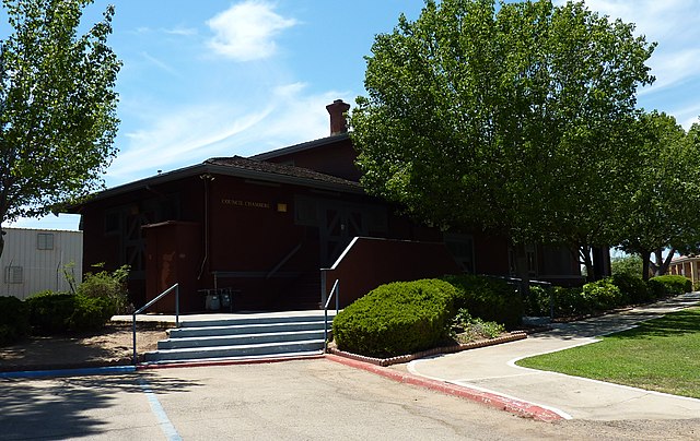
 The Orange Cove Santa Fe Railway Depot now serves as City Hall and is also listed on the National Register of Historic Places. | |||
| |||
 Location in Fresno County and the U.S. state of California | |||
ഓറഞ്ച് കോവ്, കാലിഫോർണിയ Location in the United States | |||
| Coordinates: 36°37′28″N 119°18′49″W / 36.62444°N 119.31361°W | |||
| Country | United States | ||
| State | California | ||
| County | Fresno | ||
| Incorporated | January 20, 1948[1] | ||
| • Mayor | Victor P. Lopez[2] | ||
| • Mayor Pro Tem | Diana Guerra Silva[2] | ||
| • State Senator | Andy Vidak (R)[3] | ||
| • Assemblymember | Joaquin Arambula (D)[4] | ||
| • U. S. Rep. | Devin Nunes (R)[5] | ||
| • ആകെ | 1.912 ച മൈ (4.951 ച.കി.മീ.) | ||
| • ഭൂമി | 1.912 ച മൈ (4.951 ച.കി.മീ.) | ||
| • ജലം | 0 ച മൈ (0 ച.കി.മീ.) 0% | ||
| ഉയരം | 423 അടി (129 മീ) | ||
(2010) | |||
| • ആകെ | 9,078 | ||
| • ജനസാന്ദ്രത | 4,700/ച മൈ (1,800/ച.കി.മീ.) | ||
| സമയമേഖല | UTC-8 (PST) | ||
| • Summer (DST) | UTC-7 (PDT) | ||
| ZIP codes | 93646, 93675 | ||
| Area code | 559 | ||
| FIPS code | 06-54008 | ||
| GNIS feature IDs | 277569, 2411327 | ||
| വെബ്സൈറ്റ് | www | ||

.png)

- ↑ "California Cities by Incorporation Date". California Association of Local Agency Formation Commissions. Archived from the original (Word) on 2013-10-17. Retrieved April 6, 2013.
- ↑ 2.0 2.1 "City Council". City of Orange Cove. Retrieved January 5, 2015.
- ↑ "Senators". State of California. Retrieved April 6, 2013.
- ↑ "Members Assembly". State of California. Retrieved April 6, 2013.
- ↑ "California's 22-ആം Congressional District - Representatives & District Map". Civic Impulse, LLC. Retrieved April 6, 2013.
- ↑ "2010 Census U.S. Gazetteer Files – Places – California". United States Census Bureau.
- ↑ 7.0 7.1 "Orange Cove". Geographic Names Information System. United States Geological Survey.
- ↑ Durham, David L. (1998). California's Geographic Names: A Gazetteer of Historic and Modern Names of the State. Clovis, Calif.: Word Dancer Press. p. 1084. ISBN 1-884995-14-4.