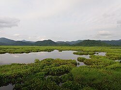
కోక్రాఝర్ జిల్లా
Contributors to Wikimedia projects
 Article Images
కోక్రాఝర్ జిల్లా
అస్సాం లోని జిల్లా
(కోక్రఝార్ జిల్లా నుండి దారిమార్పు చెందింది)
అస్సాం రాష్ట్రం లోని 27 జిల్లాలలో కోక్రఝార్ జిల్లా (అస్సాం:কোকৰাঝাৰ জিলা) ఒకటి. కోక్రఝార్ పట్టణం జిల్లాకేంద్రంగా ఉంది. జిల్లా వైశాల్యం 3,169చ.కి.మీ. జనసంఖ్య 905,764. వీరిలో హిందువులు 594,168, ముస్లిములు 184,441 (20.36%). ఈశాన్య భారత్కు కోక్రఝార్ ద్వారంగా ఉంది. రైల్వే, రహదార్లు సమీప రాష్ట్రాలకు అనుసంధానమై ఉన్నాయి.
కోక్రఝార్ జిల్లా কোকৰাঝাৰ জিলা | |
|---|---|
జిల్లా | |
 డిప్లై బీల్ సరస్సు | |
 Map of Kokrajhar district in Assam | |
| Country | భారత దేశము |
| State | అసోం |
| ప్రధాన కార్యాలయం | కోక్రఝార్ |
| విస్తీర్ణం | |
| • Total | 3,129 కి.మీ2 (1,208 చ. మై) |
| జనాభా (2011) | |
| • Total | 8,86,999 |
| • జనసాంద్రత | 280/కి.మీ2 (730/చ. మై.) |
| Time zone | UTC+05:30 (IST) |
| Website | kokrajhar.gov.in |
కోక్రఝార్ జిల్లా మునుపు గోల్పరా జిల్లాలో భాగంగా ఉంటూ వచ్చింది. 1957 అప్పటి అస్సాం ముఖ్యమంత్రి బిమ్లా ప్రసాద్ చలిహ ఆధ్వర్యంలో 3 ఉపవిభాగాలు చేయబడ్డాయి. వాటిలో ఒకటి కోక్రఝార్. 1983 జూలై 1న కోక్రఝార్ జిల్లాగా రూపొందించబడింది.[1]1989లో కోక్రఝార్, గోల్పరా జిల్లాలో కొంత భూభాగం వేరుచేసి బొంగైగావ్ జిల్లా ఏర్పాటు చేయబడింది.[1]
కోక్రఝార్ జిల్లా వైశాల్యం 3129చ.కి.మీ., [2] రష్యాలోని వైగోద్వీపంతో సమానం. .[3] కోక్రఝార్ జిల్లా బ్రహ్మపుత్రానది ఉత్తరతీరంలో ఉంది. ఇది ఈశాన్య భారతంలోని 7 రాష్ట్రాలకు ద్వారంగా ఉంది. కోక్రఝార్ జిల్లా సరిహద్దులలో బొంగైగావ్ జిల్లా, (ప్రస్తుతం ఇది చిరంగ్ జిల్లా), ధుబ్రి (పశ్చిమ బెంగాల్) బార్పేట, భూటాన్ ఉన్నాయి.
- జిల్లాలో మనస్ నేషనల్ పార్క్లో కొంతభాగం ఉంది.
2006 గణాంకాలను అనుసరించి పచాయితీ రాజ్ మంత్రిత్వశాఖ భారతదేశ జిల్లాలు (640) లో వెనుకబడిన 250 జిల్లాలలో కోక్రఝార్ జిల్లా ఒకటి అని గుర్తించింది.[4] బ్యాక్వర్డ్ రీజన్ గ్రాంటు ఫండు నుండి నిధులను అందుకుంటున్న అస్సాం రాష్ట్ర11జిల్లాలలో ఈ జిల్లా ఒకటి.[4]
| విషయాలు | వివరణలు |
|---|---|
| జిల్లా జనసంఖ్య . | 886,999, [7] |
| ఇది దాదాపు. | ఫిజి దేశ జనసంఖ్యకు సమానం.[8] |
| అమెరికాలోని. | నగర జనసంఖ్యకు సమం. |
| 640 భారతదేశ జిల్లాలలో. | 467వ స్థానంలో ఉంది.[7] |
| 1చ.కి.మీ జనసాంద్రత. | 280 [7] |
| 2001-11 కుటుంబనియంత్రణ శాతం. | 5.19%.[7] |
| స్త్రీ పురుష నిష్పత్తి. | 958:1000 [7] |
| జాతియ సరాసరి (928) కంటే. | అధికం |
| అక్షరాస్యత శాతం. | 66.63%.[7] |
| జాతియ సరాసరి (72%) కంటే. | తక్కువ |
| Religion in Kokrajhar district[9] | ||||
|---|---|---|---|---|
| Religion | Percent | |||
| Hindu | 65.60% | |||
| Islam | 20.36% | |||
| Christianity | 13.72% | |||
| Others | 0.32% | |||
| Ethnic Groups in Kokrajhar district | ||||
|---|---|---|---|---|
| Language | Percent | |||
| Bodo | 32.37% | |||
| Bengali | 21.06% | |||
| Assamese | 20.28% | |||
| Santhal | 16.70% | |||
జిల్లాలో వివిధ సంప్రదాయాలకు చెందిన ప్రజలు నివసిస్తున్నారు. వీరిలో ప్రత్యేకమైన ఎవరికి ఆధిక్యత లేదు. బోడో, అస్సామీ ప్రజలలో అత్యధింగా హిందువులు, స్వల్పంగా క్రైస్తవులు ఉన్నారు. బెంగాలీ ప్రజలు దాదాపు అందరూ ముస్లిములుగా ఉన్నారు. శాంతల్ ప్రజలలో 90% క్రైస్తవులు ఉన్నారు.[10]
- ఆంతై గ్వాలయొ : చంద్రపరా సమీపంలో గ్వారంగ్ నదీ సమీపంలో ఉంది.
- మాహామాయా : ఇది కోక్రఝార్, దుబ్రి సరిహద్దులో ఉంది.
- తండ్వి బినేశ్వర్ బ్రహ్మ మెమోరియల్ పార్క్ : ఇది గ్వరంగ్ నదీ తీరంలోబతేర్మరీ వద్ద ఉంది.
- డైమలు పార్క్ : ఇది ఖరిగయాన్లో ఉంది.
1990లో కోక్రఝార్ జిల్లాలో 500 చ.కి.మీ వైశాల్యంలో " మనస్ నేషనల్ పార్క్ " స్థాపించబడింది.[11] ఈ జిల్లా ఈ పార్క్ ను 4 ఇతర జిల్లాలతో పంచుకుంటుంది. .
- బినేశ్వర్ బ్రహ్మ : కవి, రచయిత.
- ఉపేంద్రనాథ్ బ్రహ్మ : బోడో నాయకుడు.
- రంజిత్ శేఖర్ మూషహరీ : ఐ.పి.ఎస్ అధికారి, నేషనల్ సెక్యూరిటీ గార్డ్స్ డైరెక్టర్ జనరల్, బార్డర్ సెక్యూరిటీ ఫోర్స్, మేఘాలయ గత గవర్నర్.
- సంసుమ ఖుంగూర్ బ్విశ్వమూతియరీ : బోడో భూమి రాజకీయనాయకుడు, జాతీయవాది, సాంఘిక వాది.
- ↑ 1.0 1.1 Law, Gwillim (2011-09-25). "Districts of India". Statoids. Retrieved 2011-10-11.
- ↑ Srivastava, Dayawanti (2010). "States and Union Territories: Assam: Government". India 2010: A Reference Annual (54th ed.). New Delhi, India: Additional Director General, Publications Division, Ministry of Information and Broadcasting (India), Government of India. pp. 1116. ISBN 978-81-230-1617-7. Retrieved 2011-10-11.
- ↑ "Island Directory Tables: Islands by Land Area". United Nations Environment Program. 1998-02-18. Archived from the original on 2018-02-20. Retrieved 2011-10-11.
Waigeo 3,154km2
- ↑ 4.0 4.1 Ministry of Panchayati Raj (September 8, 2009). "A Note on the Backward Regions Grant Fund Programme" (PDF). National Institute of Rural Development. Archived from the original (PDF) on 2012-04-05. Retrieved September 27, 2011.
- ↑ 5.0 5.1 "List of Assembly Constituencies showing their Revenue & Election District wise break - up" (PDF). Chief Electoral Officer, Assam website. Archived from the original (PDF) on 22 మార్చి 2012. Retrieved 26 September 2011.
- ↑ "List of Assembly Constituencies showing their Parliamentary Constituencies wise break - up" (PDF). Chief Electoral Officer, Assam website. Archived from the original (PDF) on 22 మార్చి 2012. Retrieved 26 September 2011.
- ↑ 7.0 7.1 7.2 7.3 7.4 7.5 "District Census 2011". Census2011.co.in. 2011. Retrieved 2011-09-30.
- ↑ US Directorate of Intelligence. "Country Comparison:Population". Archived from the original on 2011-09-27. Retrieved 2011-10-01.
Fiji 883,125 July 2011 est.
- ↑ District Report - KOKRAJHAR Archived 2017-03-29 at the Wayback Machine Ministry of Minority Affairs, Govt of India
- ↑ Census 2001
- ↑ Indian Ministry of Forests and Environment. "Protected areas: Assam". Archived from the original on 2011-08-23. Retrieved September 25, 2011.