U Thant Island: Difference between revisions - Wikipedia
 Article Images
Line 1:
{{short description|Islet on the East River in New York City}}
{{Use mdy dates|date=DecemberJuly 20182024}}
{{Infobox islands
| name = U Thant Island
| image_name = UThantIsland.jpg▼
|local_name =
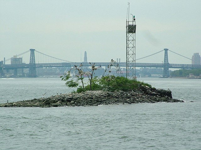
| image_caption = U Thant Island from the north, with the [[Williamsburg Bridge]] in the background▼
▲|image_name = UThantIsland.jpg
|image_map = {{maplink|frame=yes|plain=yes|frame-align=center|frame-lat=40.735|frame-long=-73.975|zoom=9|type=point|coord={{coord|40.746599|-73.964387}}}}▼
▲|image_caption= U Thant Island from the north, with the [[Williamsburg Bridge]] in the background
|coordinates = {{coord|40.746599|-73.964387|region:US_type:landmark|format=dms|display=title,inline}}▼
▲|image_map = {{maplink|frame=yes|plain=yes|frame-align=center|frame-lat=40.735|frame-long=-73.975|zoom=9|type=point|coord={{coord|40.746599|-73.964387}}}}
| country = [[United States]]▼
|pushpin_map =
| country_admin_divisions_title = State▼
|pushpin_relief =
| country_admin_divisions = [[New York (state)|New York]]▼
|pushpin_map_caption =
| country_admin_divisions_title_1 = [[Borough (New York City)|boroughBorough]]▼
|nickname =
| country_admin_divisions_1 = [[Manhattan]]▼
|location =
▲|coordinates = {{coord|40.746599|-73.964387|region:US_type:landmark|display=title,inline}}
|total_islands=
|area_km2 =
|length_km =
|width_km =
|highest_mount=
|elevation_m =
|population =
|population_as_of =
|density_km2 =
|ethnic_groups=
▲|country = [[United States]]
▲| country_admin_divisions_title = State
▲| country_admin_divisions = [[New York (state)|New York]]
▲| country_admin_divisions_title_1 = [[Borough (New York City)|borough]]
▲| country_admin_divisions_1 = [[Manhattan]]
}}
'''U Thant Island''' (officially '''Belmont Island''') is a small [[artificial island]] or [[islet]] in the [[Borough (New York City)|borough]] of [[Manhattan]] in [[New York City]]. The {{convert|100|by|200|ft|round=5|m|adj=on}} island, created during the construction of the [[Steinway Tunnel]] directly underneath, is the smallest island in Manhattan.<ref>{{cite web | title=New York's Treasure Trove of Tiny Islands | website=MetroFocus | last=Duffy | first=Karen | date=October 11, 2011 | url=https://www.thirteen.org/metrofocus/2011/10/the-archipelago-of-new-york-city/ | access-date=July 12, 2019}}</ref><ref>{{cite web | last=Frishberg | first=Hannah | title=Get To Know 34 of New York City's Most Obscure Islands | website=Curbed NY | date=August 26, 2014 | url=https://ny.curbed.com/maps/get-to-know-34-of-new-york-citys-most-obscure-islands | access-date=July 12, 2019}}</ref>▼
[[File:U Thant Island from West.jpg|thumb|300px|right|U Thant Island from the west-southwest]]▼
▲'''U Thant Island''' (officially '''Belmont Island''') is a small [[artificial island]] or [[islet]] in the [[Borough (New York City)|borough]] of [[Manhattan]] in [[New York City]]. The {{convert|100|by|200|ft|round=5|m|adj=on}} island, created during the construction of the [[Steinway Tunnel]], is the smallest island in Manhattan.<ref>{{cite web | title=New York's Treasure Trove of Tiny Islands | website=MetroFocus | date=October 11, 2011 | url=https://www.thirteen.org/metrofocus/2011/10/the-archipelago-of-new-york-city/ | access-date=July 12, 2019}}</ref><ref>{{cite web | last=Frishberg | first=Hannah | title=Get To Know 34 of New York City's Most Obscure Islands | website=Curbed NY | date=August 26, 2014 | url=https://ny.curbed.com/maps/get-to-know-34-of-new-york-citys-most-obscure-islands | access-date=July 12, 2019}}</ref>
==Location and jurisdiction==
The tiny [[artificial island]] is {{convert|100|by|200|ft|round=5|m}} in size and located in the [[East River]], just south of [[Roosevelt Island]].<ref>{{cite news |title=Sand, Surf and Shoobies |first=Jennifer |last=Mascia |url=https://query.nytimes.com/gst/fullpage.html?res=9A00EEDB1331F936A35754C0A96F9C8B63 |newspaper=[[The New York Times]] |date=July 5, 2009 |accessdateaccess-date=February 28, 2010}}</ref><ref name="Chart 12335">{{cite map |publisher=[[National Oceanic and Atmospheric Administration]] |title=Chart 12335 |url=http://www.charts.noaa.gov/OnLineViewer/12335.shtml |date=April 1, 2009 |scale=1 : 10,000 |accessdateaccess-date=February 28, 2010}}</ref> It lies midway between the [[United Nations Headquarters]] at [[42nd Street (Manhattan)|42nd Street]], in [[Manhattan]] to the west, and [[Gantry Plaza State Park]] in [[Long Island City]], within [[Queens]] to the east. It is legally part of Manhattan and is formally a part of [[Manhattan Community Board 6|Manhattan Community District 6]], which also includes the neighborhoods of [[Turtle Bay, Manhattan|Turtle Bay]] and [[Murray Hill, Manhattan|Murray Hill]] to the west of U Thant Island.<ref name="NYCPlanning">{{cite web|title=NYC Planning {{!}} Community Profiles|url=https://communityprofiles.planning.nyc.gov/manhattan/6|website=communityprofiles.planning.nyc.gov|publisher=New York City Department of City Planning|accessdateaccess-date=March 18, 2019}}</ref>
The island is owned by the [[Government of New York (state)|New York State Government]] and is currently protected as a [[nature reserve|sanctuary]] for [[bird migration|migrating birds]], including a small colony of [[double-crested cormorant]]s. The cormorant population more than doubled from 2000–112000 to 2011.<ref>{{Cite web|url=https://www.nps.gov/gate/learn/nature/upload/Elbin-and-Craig-DCCO-2011-Dec-5.pdf|title=Cormorant Population in the NY Harbor 2005–2011|lastlast1=Elbin|firstfirst1=Susan|last2=Craig|first2=Liz|date=December 5, 2011|website=National Park Service|publisher=New York City Audubon|archiveaccess-date=December 18, 2018|url-status=dead|archive-dateurl=https://web.archive.org/web/20181219044257/https://www.nps.gov/gate/learn/nature/upload/Elbin-and-Craig-DCCO-2011-Dec-5.pdf|accessarchive-date=December 1819, 2018}}</ref> The [[Borough, Block and Lot]] is Manhattan, Block 1373 (shared with Roosevelt Island), and Lot 200.<ref>{{Cite web|url=https://a836-pts-access.nyc.gov/care/datalets/datalet.aspx?UseSearch=no&pin=1013730200|title=NYC Finance|website=a836-pts-access.nyc.gov|access-date=2019-07-July 23, 2019}}</ref> Public access is prohibited.<ref name="nyt-1996-10-06">{{cite news |title=F.Y.I. |first=Daniel B. |last=Schneider |url=https://www.nytimes.com/1996/10/06/nyregion/fyi-652520.html |newspaper=[[The New York Times]] |date=October 6, 1996 |accessdate=February 28, 2010}}</ref><ref>{{cite news |title=A Cleaner Harbor Lures Water Birds to New York |first=Jane E. |last=Brody |url=https://www.nytimes.com/1998/09/08/science/a-cleaner-harbor-lures-water-birds-to-new-york.html |newspaper=[[The New York Times]] |date=September 8, 1998 |accessdateaccess-date=February 28, 2010}}</ref><ref>{{cite news |first=Joseph |last=Berger |authorlinkauthor-link=Joseph Berger (author) |title=So, You Were Expecting a Pigeon?; In City Bustle, Herons, Egrets and Ibises Find a Sanctuary |work=[[The New York Times]] |date=December 4, 2003 |url=https://www.nytimes.com/2003/12/04/nyregion/so-you-were-expecting-pigeon-city-bustle-herons-egrets-ibises-find-sanctuary.html |accessdateaccess-date=July 12, 2009}}</ref> Since 2016, the island has been designated a Recognized Ecological Complex under the city's Waterfront Revitalization Program.<ref>{{Cite web|url=https://www1.nyc.gov/site/planning/applicants/wrp/wrp.page|title=The Waterfront Revitalization Program Overview - DCP|website=www1.nyc.govNew York City Department of City Planning|access-date=December 18, 2018}}</ref><ref>{{Cite web|url=https://www1www.nyc.gov/site/planning/applicants/wrp/wrp-2.page|title=The Waterfront Revitalization Program Maps & Policie - DCPPolicies|website=www1.nyc.govNew York City Department of City Planning|access-date=December 18, 2018}}</ref> The reefs in the waters surrounding the island make it a popular spot for boats fishing for [[striped bass]].<ref>{{cite news |title=Some Special Spots in Shadow of Skyline |first=Peter |last=Kaminsky |url=https://www.nytimes.com/2004/11/07/sports/othersports/07outdoors.html |newspaper=[[The New York Times]] |date=November 7, 2004 |accessdateaccess-date=February 28, 2010}}</ref><ref>{{Cite book|url=https://books.google.com/books?id=qrZ5bi5gpI4C&pg=PA287|title=Flyfisher's Guide to the Northeast Coast|last=Shook|first=Phil|date=February 2009|publisher=Wilderness Adventures Press|page=287|isbn=9781932098679}}</ref> The [[United States Coast Guard]] maintains a 57-foot (17 m) tall lighted [[beacon]] on the island, designated "Roosevelt Island Reef Light 17";<ref>{{Cite web|url=http://www.charts.noaa.gov/OnLineViewer/12335.shtml|titlename="Chart 12335|website=www.charts.noaa.gov|access-date=2018-12-19}}<"/ref><ref>{{Cite web|url=https://navcen.uscg.gov/?pageName=lightListWeeklyUpdatessites/default/files/pdf/lightLists/LightList_V1_2023.pdf|title=Light List, First District -– Volume I|last=|first=|date=20192023|website=United States Coast Guard, Navigation Center|at=HUDSON AND EAST RIVERS (Chart 12335). Light list number 27315.|archive-url=|archive-date= p. 243|access-date=2019-07-12March 9, 2023}}</ref> an earlier 23-foot (7 m) tall light had been erected in 1938,<ref>{{Cite book|url=https://books.google.com/books?id=3PSXz1Yvq50C|title=Complete List of Lights and Other Marine Aids, Atlantic Coast of the United States|date=1954|publisher=U.S. Government Printing Office}}</ref> and another pair before then.<ref>{{Cite book|url=https://books.google.com/books?id=1SoxAQAAMAAJ&pg=PA27|title=The New York Pilot and Guide to the United States Local Inspectors Examination of Masters and Pilots for New York Bay and Harbor to Yonkers and Great Captain Island: And a Complete New York Pilot Containing All Useful Information|last=Pugsley|first=Richard Marriotte|date=1910|publisher=R.M. Pugsley}}</ref>
[[Sea level|Mean sea level]] in the East River is sometimes measured in reference to the "Belmont Island Datum", 2.265 feet (0.69 m) below that of [[Sandy Hook, New Jersey|Sandy Hook]].
==History==
In the 1890s, businessman [[William Steinway]] constructedbegan thea twoproject [[Steinwayto Tunnels]]construct a tunnel for trolleys under the East River to link [[Manhattan]] to his also eponymous [[company town]], [[Ditmars, Queens|Steinway Village]], in [[Astoria, Queens]]; the tunnel would be named the [[Steinway Tunnel]] after him. As part of thatthis construction project, a [[Shaft mining|shaft]] dug into the [[granite]] outcrop known as '''Man-o'-War Reef''' to reach the tunnels produced excess [[land reclamation|landfill]] that built up the reef and created a small island. Steinway died before his tunnels' completion, and financier [[August Belmont Jr.]] finishedsaw the project into completion between 1905 and 1907. Belmont Island, named after the financier, became the legal name of the island. Four workers were killed in a 1906 shaft accident under the island.<ref>{{Cite webnews|url=https://cdnc.ucr.edu/?a=d&d=LAH19060117.2.18&e=-------en--20--1--txt-txIN--------1|title=Four Lose Their Lives in Tunnel Disaster|work=Los Angeles Herald 17 |date=January 17, 1906 — |via=California Digital Newspaper Collection|website=cdnc.ucr.edu|access-date=2018-12-December 20, 2018}}</ref> The tunnels, which pass directly beneath the island, are still used by the [[IRT Flushing Line]] ({{NYCS trains|Flushing}}), and are now part of the [[New York City Subway]] system.<ref>{{cite journal |last=Rogoff |first=David |year=1960 |url=http://nycsubway.org/wiki/The_Steinway_Tunnels_%281960%29 |title=The Steinway Tunnels |journal=Electric Railroads |issue= 29}}</ref> Buildings from the tunnel stayed up until at least 1918.<ref>{{Citecite book | author=New York (N.Y.) | title=The City Record: Official Journal | issue=v. 46, pt. 7 | year=1918 | url=https://books.google.com/books?id=EYc-AQAAMAAJ&pg=PA3540 |title access-date=TheMay City26, Record:2020 Official Journal|last=York (N.Y.)|firstpage=New|date=19183540}}</ref>▼
[[File:U Thant Island construction 1906.jpg|thumb|300px|Newly-built island in 1906 during tunnel construction.]]▼
▲In the 1890s, [[William Steinway]] constructed the two [[Steinway Tunnels]] for trolleys under the East River to link [[Manhattan]] to his also eponymous [[company town]], [[Ditmars, Queens|Steinway Village]], in [[Astoria, Queens]]. As part of that construction project, a [[Shaft mining|shaft]] dug into the [[granite]] outcrop known as '''Man-o'-War Reef''' to reach the tunnels produced excess [[land reclamation|landfill]] that built up the reef and created a small island. Steinway died before his tunnels' completion, and financier [[August Belmont Jr.]] finished the project in 1907. Belmont Island, named after the financier, became the legal name of the island. Four workers were killed in a 1906 shaft accident under the island.<ref>{{Cite web|url=https://cdnc.ucr.edu/?a=d&d=LAH19060117.2.18&e=-------en--20--1--txt-txIN--------1|title=Los Angeles Herald 17 January 1906 — California Digital Newspaper Collection|website=cdnc.ucr.edu|access-date=2018-12-20}}</ref> The tunnels, which pass directly beneath the island, are still used by the [[IRT Flushing Line]] ({{NYCS trains|Flushing}}), and are now part of the [[New York City Subway]] system.<ref>{{cite journal |last=Rogoff |first=David |year=1960 |url=http://nycsubway.org/wiki/The_Steinway_Tunnels_%281960%29 |title=The Steinway Tunnels |journal=Electric Railroads |issue= 29}}</ref> Buildings from the tunnel stayed up until at least 1918.<ref>{{Cite book|url=https://books.google.com/books?id=EYc-AQAAMAAJ&pg=PA3540|title=The City Record: Official Journal|last=York (N.Y.)|first=New|date=1918}}</ref>
In 1964, the {{convert|33,310|ST|0|sp=us|adj=on}} Norwegian fuel oil tanker ''[[Sigdal]]'' ran aground on the island, imperiling East River traffic.<ref>{{Cite news|url=https://www.nytimes.com/1964/02/08/archives/631foot-tanker-runs-aground-on-belmont-island-in-the-east-river.html|title=631‐Foot Tanker Runs Aground on Belmont Island in the East River|date=February 8, 1964|work=The New York Times|access-date=December 18, 2018|issn=0362-4331}}</ref><ref>{{Cite news|url=https://www.nytimes.com/1964/02/09/archives/tanker-teeters-on-rock-near-ui-salvage-crews-drawing-off.html|title=TANKER TEETERS ON ROCK NEAR UIU.N.; Salvage Crews Drawing Off Oii‐‐FireboatsOil‐‐Fireboats Stand By|date=February 9, 1964|work=The New York Times|access-date=December 18, 2018|issn=0362-4331}}</ref><ref>{{Cite news|url=https://www.nytimes.com/1964/02/11/archives/talks-break-off-in-tug-walkout-no-new-meetings-scheduled-emergency.html|title=TALKS BREAK OFF IN TUG WALKOUT; No New Meetings Scheduled —Emergency Steps Taken|date=February 11, 1964|work=The New York Times|access-date=December 18, 2018|issn=0362-4331}}</ref>
In 1968, the [[Hudson Institute]] published a proposal for connecting Roosevelt Island and U Thant Island by landfill to form a single larger island, as part of an economic redevelopment. [[42nd Street (Manhattan)|42nd Street]] would have extended across the island from Manhattan to Queens, connected by a [[Ponte Vecchio]]-like bridge covered in shops. "Belmont Center", modeled on [[Rockefeller Center]], would have had towers of up to 80 stories.<ref>{{Cite news|url=https://www.newyorker.com/magazine/1969/02/22/1969-to-2019|title=1969 to 2019|last=Brodeur|first=Paul|date=1969-02-February 15, 1969|work=The New Yorker|access-date=December 19, 2018-12-19|issn=0028-792X}}</ref><ref>{{Cite book|url=https://books.google.com/books?id=fzeODQAAQBAJ&pg=PA458|title=On His Own Terms: A Life of Nelson Rockefeller|last=Smith|first=Richard Norton|date=2014|publisher=Random House|isbn=9780375505805}}</ref><ref>{{Cite book|url=https://books.google.com/books/about/A_preliminary_approach_to_East_river_dev.html?id=7KElAQAAIAAJ|title=A preliminaryPreliminary approachApproach to East riverRiver developmentDevelopment|lastauthor1=Hudson Institute|first=Hudson|last2=Panero|first2=Robert|date=1968|publisher=Croton-on-Hudson}}</ref>
A [[Jet d'Eau]]-like–like fountain sponsored by [[George T. Delacorte Jr.]] stood nearby on Roosevelt Island from 1969- to 1987, and faced calls for its relocation to U Thant Island due to environmental hazards throughout its existence, at the time of its installation, in a 1972-741972–74 lawsuit, and at the time it was finally demolished.<ref>{{Cite news|url=https://www.nytimes.com/1972/12/30/archives/a-suit-seeks-to-save-delacorte-fountain.html|title=A Suit Seeks to Save Delacorte Fountain|last=Waggoner|first=Walter H.|date=1972-12-December 30, 1972|work=The New York Times|access-date=December 24, 2018-12-24|issn=0362-4331}}</ref><ref>{{Cite news|url=https://www.nytimes.com/1987/09/28/nyregion/metro-matters-good-intentions-on-quirky-geyser-go-slightly-awry.html|title=Metro Matters; Good Intentions On Quirky Geyser Go Slightly Awry|last=Roberts|first=Sam|date=1987-09-September 28, 1987|work=The New York Times|access-date=2018-12-December 24, 2018|issn=0362-4331}}</ref>
In 1972, the island was declared "[[Soviet Jewry Movement|Soviet Jewry]] Freedom Island" and [[Occupation (protest)|symbolically occupied]] for {{frac|2½|1|2}} hours by activists led by Manhattan and Bronx Borough Presidents [[Percy Sutton]] and [[Robert Abrams]] to protest a United Nations speech by [[Leonid Brezhnev]] and the imposition of the [[diploma tax]] as a barrier to emigration from the Soviet Union.<ref>{{Cite news|url=https://www.nytimes.com/1972/08/26/archives/isle-at-un-occupied-in-a-jewish-protest.html|title=Isle at U.N. ‘Occupied’'Occupied' Inin a Jewish Protest|date=August 26, 1972|work=The New York Times|access-date=December 18, 2018|issn=0362-4331}}</ref><ref>{{Cite web|url=https://www.jta.org/2009/12/30/united-states/remembrance-percy-sutton-champion-of-the-soviet-jewry-cause|title=Remembrance: Percy Sutton, champion of the Soviet Jewry cause|date=December 30, 2009|last=Hoenlein|first=Malcolm|website=Jewish Telegraphic Agency|access-date=December 18, 2018}}</ref>
[[File:Chrysler and UN buildings.jpg|thumb|left|200px|The [[Chrysler Building|Chrysler]] and [[HeadquartersUnited ofNations theSecretariat United Nations|UNBuilding]] buildings, with U Thant Island in the foreground]]
In 1977, the island was adopted by a group called the Peace Meditation at the United Nations, employees at the United Nations Headquartersheadquarters and followers of the guru [[Sri Chinmoy]], who served as the interfaith chaplain there. They leased the island from New York State, greened its surface, and unofficially renamed it after the Burmese former [[United Nations Secretary General]] [[U Thant]], a friend of Chinmoy. AlthoughIn unofficial1982, Belmont Island was officially rededicated as U Thant Island.<ref>{{Cite hasnews|last=Haberman|first=Clyde|last2=Johnston|first2=Laurie|date=October become8, the1982|title=New commonYork nameDay by Day|language=en-US|work=The New York Times|url=https://www.nytimes.com/1982/10/08/nyregion/new-york-day-by-day-206868.html|access-date=July 28, 2022|issn=0362-4331}}</ref><ref>{{cite news |last=King |first=Martin |date=October 8, 1982 |url=https://www.newspapers.com/clip/122847094/in-the-east-river-an-island-just-for-u/ |title=In the islandEast River, an Island just for U |work=Daily News |location=New York |via=[[Newspapers.com]] |access-date=April 14, 2023}}</ref> It is now the site of a metal "oneness arch", preserving personal items of the island's namesake.<ref name="nyt-1996-10-06">{{cite news |title=F.Y.I. |first=Daniel B. |last=Schneider |url=https://www.nytimes.com/1996/10/06/nyregion/fyi-652520.html |newspaper=[[The New York Times]] |date=October 6, 1996 |access-date=February 28, 2010}}</ref><ref>{{cite news |last=Baard |first=Erik |title=Holy Waters | work=[[The Village Voice]] |location=New York |date=June 4, 2002 |url=httphttps://www.villagevoice.com/2002-/06-/04/news/holy-waters |accessdateaccess-date=JulyFebruary 1216, 20092021}}</ref>
In 1999, ''[[The New York Times Magazine]]'' staged an international competition to design a [[time capsule]] to preserve artifacts for the next millennium. An entry by [[Caples Jefferson Architects]] proposed a granite obelisk on U Thant Island that would gradually disintegrate, leaving only the time capsule by the end of the 30th century.<ref>{{cite news |first=Herbert |last=Muschamp |authorlinkauthor-link=Herbert Muschamp |title=Designs for the Next Millennium. Caples Jefferson |work=[[The New York Times]] |date=December 5, 1999 |url=https://www.nytimes.com/1999/12/05/magazine/designs-for-the-next-millennium-caples-jefferson.html |accessdateaccess-date=July 12, 2009}}</ref>
During the [[2004 Republican National Convention]], local artist and filmmaker [[Duke Riley (artist)|Duke Riley]], who has traveled to various abandoned islands around the New York City area, rowed a boat with a friend to the island under cover of darkness, proclaimed it a sovereign nation and hoisted a {{convert|21|ft|m|adj=on}}-long pennant depicting two electric eels from the island's navigation tower. On their return voyage in daylight, they were apprehended by a [[United States Coast Guard]] boat but were not arrested. The entire incident was videotaped for a piece Riley titled ''Belmont Island (SMEACC)''.<ref>{{cite news |last=Tudor |first=Silke |title=Life of Riley |work=[[The Village Voice]] |location=New York |date=May 23, 2006 |url=http://www.villagevoice.com/2006-05-23/nyc-life/life-of-riley/ |accessdateaccess-date=July 12, 2009 |url-status=dead |archive-url=https://web.archive.org/web/20080922103413/http://www.villagevoice.com/2006-05-23/nyc-life/life-of-riley/ |archive-date=September 22, 2008}}</ref>
<gallery mode="packed" height="240">
{{-|left}}
▲[[File:U Thant Island construction 1906.jpg|thumb|300pxalt= island surrounded by barges|Newly-built island in 1906 during tunnel construction.]]
▲[[File:U Thant Island from West.jpg|thumb|300px|rightalt= tiny island with metal structure on it|U Thant Island from the west-southwest]]
File:U Thant Island.jpg |alt= islet with bridges behind it |View of the islet from the south
</gallery>
==References==
{{Portal|New York City}}▼
{{reflist}}
▲{{Portal|New York City}}
==External links==
{{commons category|U Thant Island}}
* [[Forgotten NY]]: [http://forgotten-ny.com/1999/05/an-island-just-for-u/ An Island just for U] and [http://forgotten-ny.com/2001/03/the-new-york-islands/ ...to the New York Islands]
* NYC Audubon Harbor Herons Project: [https://web.archive.org/web/20120205093255/http://www.nycaudubon.org/projects/harborherons/HHSurveyReports.shtml Harbor Herons Nesting Survey], recent2004–2011 reports on cormorant and gull nesting activity at U Thant Island
* NYCSubway.org: [http://www.nycsubway.org/wiki/The_Steinway_Tunnels_(1960) The Steinway Tunnels]