 Article Images
Content deleted Content added
m |
|||
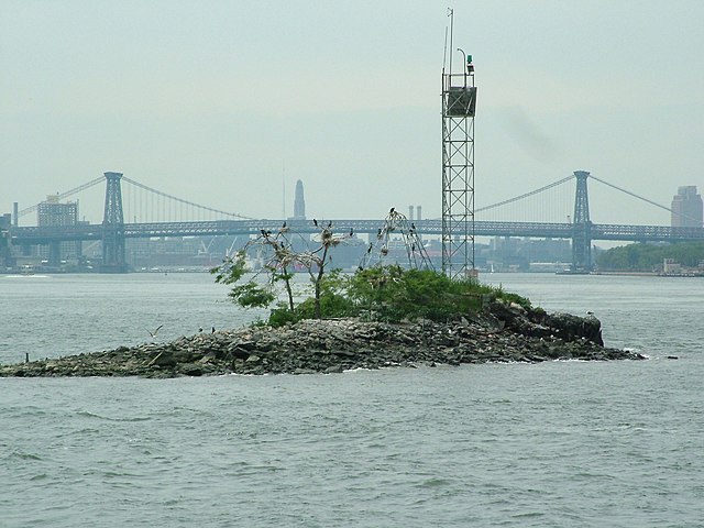
Line 35: The tiny [[artificial island]] is {{convert|100|by|200|ft|round=5|m}} in size and located in the [[East River]], just south of [[Roosevelt Island]].<ref>{{cite news |title=Sand, Surf and Shoobies |first=Jennifer |last=Mascia |url=https://query.nytimes.com/gst/fullpage.html?res=9A00EEDB1331F936A35754C0A96F9C8B63 |newspaper=[[The New York Times]] |date=July 5, 2009 |accessdate=February 28, 2010}}</ref><ref>{{cite map |publisher=[[National Oceanic and Atmospheric Administration]] |title=Chart 12335 |url=http://www.charts.noaa.gov/OnLineViewer/12335.shtml |date=April 1, 2009 |scale=1 : 10,000 |accessdate=February 28, 2010}}</ref> It lies midway between the [[United Nations Headquarters]] at [[42nd Street (Manhattan)|42nd Street]], in [[Manhattan]] to the west, and [[Gantry Plaza State Park]] in [[Long Island City]], within [[Queens]] to the east. It is legally part of Manhattan and is formally a part of [[Manhattan Community Board 6|Manhattan Community District 6]], which also includes the neighborhoods of [[Turtle Bay, Manhattan|Turtle Bay]] and [[Murray Hill, Manhattan|Murray Hill]] to the west of U Thant Island.<ref name="NYCPlanning">{{cite web|title=NYC Planning {{!}} Community Profiles|url=https://communityprofiles.planning.nyc.gov/manhattan/6|website=communityprofiles.planning.nyc.gov|publisher=New York City Department of City Planning|accessdate=March 18, 2019}}</ref> The island is owned by the [[Government of New York (state)|New York State Government]] and is currently protected as a [[nature reserve|sanctuary]] for [[bird migration|migrating birds]], including a small colony of [[double-crested cormorant]]s. The cormorant population more than doubled from 2000–11.<ref>{{Cite web|url=https://www.nps.gov/gate/learn/nature/upload/Elbin-and-Craig-DCCO-2011-Dec-5.pdf|title=Cormorant Population in the NY Harbor|last=|first=|date=December 5, 2011|website=National Park Service|publisher=New York City Audubon|archive-url=|archive-date=|dead-url=|access-date=December 18, 2018}}</ref> The [[Borough, Block and Lot]] is Manhattan, Block 1373 (shared with Roosevelt Island), and Lot 200.<ref>{{Cite web|url=https://a836-pts-access.nyc.gov/care/Search/Disclaimer.aspx?FromUrl=../search/commonsearch.aspx?mode=persprop|title=NYC Finance|website=a836-pts-access.nyc.gov|access-date=2019-07-21}}</ref> Public access is prohibited.<ref name="nyt-1996-10-06">{{cite news |title=F.Y.I. |first=Daniel B. |last=Schneider |url=https://www.nytimes.com/1996/10/06/nyregion/fyi-652520.html |newspaper=[[The New York Times]] |date=October 6, 1996 |accessdate=February 28, 2010}}</ref><ref>{{cite news |title=A Cleaner Harbor Lures Water Birds to New York |first=Jane E. |last=Brody |url=https://www.nytimes.com/1998/09/08/science/a-cleaner-harbor-lures-water-birds-to-new-york.html |newspaper=[[The New York Times]] |date=September 8, 1998 |accessdate=February 28, 2010}}</ref><ref>{{cite news |first=Joseph |last=Berger |authorlink=Joseph Berger (author) |title=So, You Were Expecting a Pigeon?; In City Bustle, Herons, Egrets and Ibises Find a Sanctuary |work=[[The New York Times]] |date=December 4, 2003 |url=https://www.nytimes.com/2003/12/04/nyregion/so-you-were-expecting-pigeon-city-bustle-herons-egrets-ibises-find-sanctuary.html |accessdate=July 12, 2009}}</ref> Since 2016, the island has been designated a Recognized Ecological Complex under the city's Waterfront Revitalization Program.<ref>{{Cite web|url=https://www1.nyc.gov/site/planning/applicants/wrp/wrp.page|title=The Waterfront Revitalization Program Overview - DCP|website=www1.nyc.gov|access-date=December 18, 2018}}</ref><ref>{{Cite web|url=https://www1.nyc.gov/site/planning/applicants/wrp/wrp-2.page|title=The Waterfront Revitalization Program Maps & Policie - DCP|website=www1.nyc.gov|access-date=December 18, 2018}}</ref> The reefs in the waters surrounding the island make it a popular spot for boats fishing for [[striped bass]].<ref>{{cite news |title=Some Special Spots in Shadow of Skyline |first=Peter |last=Kaminsky |url=https://www.nytimes.com/2004/11/07/sports/othersports/07outdoors.html |newspaper=[[The New York Times]] |date=November 7, 2004 |accessdate=February 28, 2010}}</ref><ref>{{Cite book|url=https://books.google.com/books?id=qrZ5bi5gpI4C&pg=PA287|title=Flyfisher's Guide to the Northeast Coast|last=Shook|first=Phil|date=February 2009|publisher=Wilderness Adventures Press|isbn=9781932098679}}</ref> The [[United States Coast Guard]] maintains a 57-foot (17 m) tall lighted [[beacon]] on the island, designated "Roosevelt Island Reef Light 17";<ref>{{Cite web|url=http://www.charts.noaa.gov/OnLineViewer/12335.shtml|title=Chart 12335|website=www.charts.noaa.gov|access-date=2018-12-19}}</ref><ref>{{Cite web|url=https://navcen.uscg.gov/?pageName=lightListWeeklyUpdates|title=Light List, First District - Volume I|last=|first=|date=2019|website=United States Coast Guard, Navigation Center|at=HUDSON AND EAST RIVERS (Chart 12335). Light list number 27315.|archive-url=|archive-date=|dead-url=|access-date=2019-07-12}}</ref> an earlier 23-foot (7 m) tall light had been erected in 1938,<ref>{{Cite book|url=https://books.google.com/books?id=3PSXz1Yvq50C|title=Complete List of Lights and Other Marine Aids, Atlantic Coast of the United States|date=1954|publisher=U.S. Government Printing Office}}</ref> and another pair before then.<ref>{{Cite book|url=https://books.google.com/books?id=1SoxAQAAMAAJ&pg=PA27|title=The New York Pilot and Guide to the United States Local Inspectors Examination of Masters and Pilots for New York Bay and Harbor to Yonkers and Great Captain Island: And a Complete New York Pilot Containing All Useful Information|last=Pugsley|first=Richard Marriotte|date=1910|publisher=R.M. Pugsley}}</ref> [[Sea level|Mean sea level]] in the East River is sometimes measured in reference to the "Belmont Island Datum", 2.265 feet (0.69 m) below that of [[Sandy Hook]]. | |||