File:Tristan Map.png - Wikipedia
 Article Images
Original file (2,787 × 2,441 pixels, file size: 639 KB, MIME type: image/png)
File history
Click on a date/time to view the file as it appeared at that time.
| Date/Time | Thumbnail | Dimensions | User | Comment | |
|---|---|---|---|---|---|
| current | 23:19, 9 April 2020 |  | 2,787 × 2,441 (639 KB) | Getsnoopy | Fixed formatting for DMS grid lines labels as per SI. |
| 18:55, 23 March 2017 |  | 2,787 × 2,441 (578 KB) | Jeanjung212 | Lossless Compressed/optimized png decreasing file size by 237453 bytes | |
| 20:38, 5 April 2009 |  | 2,787 × 2,441 (810 KB) | Mahahahaneapneap | Compressed | |
| 11:43, 22 April 2006 |  | 2,787 × 2,441 (853 KB) | Varp~commonswiki | ||
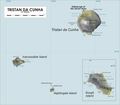
| 18:28, 19 April 2006 |  | 2,542 × 2,441 (555 KB) | Varp~commonswiki | *Map of Tristan da Cunha Group, Southern Atlantic Ocean *drawn by varp |
File usage
The following 13 pages use this file:
Global file usage
This file contains additional information, probably added from the digital camera or scanner used to create or digitize it.
If the file has been modified from its original state, some details may not fully reflect the modified file.
| Software used | Adobe Photoshop 21.1 (Windows) |
|---|---|
| Date and time of digitizing | 13:03, 9 April 2020 |
| File change date and time | 13:17, 9 April 2020 |
| Date metadata was last modified | 13:17, 9 April 2020 |
| Unique ID of original document | xmp.did:ed162471-8ff1-8d4f-b658-ad5f91c75311 |
| Horizontal resolution | 28.35 dpc |
| Vertical resolution | 28.35 dpc |
