web atlas through Wikimedia Commons about India
The introductions of the country, dependency and region entries are in the native languages and in English. The other introductions are in English.
| |
|
Atlas-country

|
|
|
|
|
|
|
|
|
|
India
|
|
|
|
| English
|
India - Republic of India
The Republic of India is a country in South Asia. It is the seventh-largest country by geographical area, the second most populous country and the largest democracy in the world. India has a coastline of over seven thousand kilometres, bounded by the Indian Ocean on the south, the Arabian Sea on the west, and the Bay of Bengal on the east. India borders ► Pakistan to the north-west; ► China (with ► Tibet), ► Nepal to the north; and ► Bangladesh, ► Bhutan to the north-east; and ► Myanmar to the east. In the Indian Ocean, India is in the vicinity of ► Sri Lanka, ► Maldives and ► Indonesia are to the south.
|
|
|
|
| Short name
|
India
|
| Official name
|
Republic of India
|
| Status
|
Independent country since 1947
|
| Location
|
South Asia
|
| Capital
|
New Delhi
|
| Population
|
1,210,854,977 inhabitants
|
| Area
|
3,287,263 square kilometres (1,269,219 sq mi)
|
| Major languages
|
Hindi (official), English (additional), 22 regional official languages[1]
|
| Major religions
|
Hinduism, Islam, Christianity, Buddhism, Sikhism, Jainism and others
|
| More information
|
India, Geography of India, History of India and Politics of India
|
| More images
|
India - India (Category).
|
|
General maps

|
Map of India
|

|
India and surrounding countries
|

|
South Asia in local languages
|

|
Physical map
|

|
Physical map of India with various physiographic divisions
|
Maps of divisions
This section holds maps of the administrative divisions.

|
Disputed territories of India
|
History maps
This section holds a short summary of the history of the area of present-day India, illustrated with maps, including historical maps of former countries and empires that included present-day India.

|
Ancient India (600 BC)
|

|
Mauryan Empire
|
|
Mauryan Empire
|

|
Mauryan Empire
|

|
Mauryan Empire
|

|
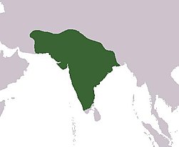
Gupta Empire
|
|
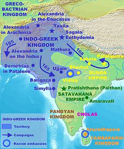
Indo-Greek Kingdom
|

|
Indo-Greek Kingdom
|

|
Kushan Empire
|

|
Gupta Empire
|
|
|
Gupta Empire
|

|
Gupta Empire
|

|
Kadamba Empire (450)
|

|
Rajput Kingdoms (7th-11th Century)
|

|
Kanauj Empire (750-900)
|

|
Rashtrakuta Empire (750-900)
|

|
Chola Empire
|

|
Chola Empire
|

|
Chola Empire
|

|
Delhi Sultanate during the Tughlaq dynasty 1320-1330
|

|
Delhi Sultanate under Iltutmish
|

|
South India in 1500
|
|
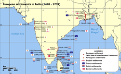
European settlements in India 1501-1739
|
|
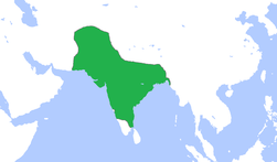
Mughal Empire
|

|
Mughal Empire
|

|
Mughal Empire 1690
|

|
India 1700-1792
|

|
French India 1741-1754
|
|
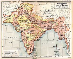
British India in 1909
|

|
Anglo-Mysore Wars
|
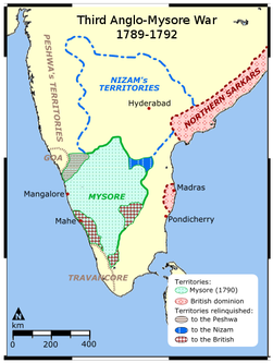
|
Anglo-Mysore Wars
|
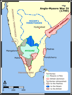
|
Anglo-Mysore Wars
|
|
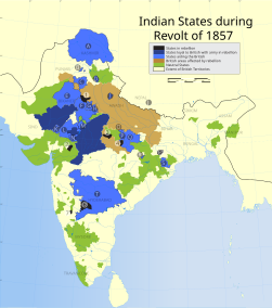
Indian Rebellion of 1857
|
Old maps
This section holds copies of original general maps more than 70 years old.

|
Hindustan in 1812 by Arrowsmith and Lewis
|
|
Map of Bengal 1893
|

|
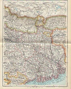
Map of Eastern Bengal and Assam 1907
|
Ethno-linguistic maps
Other maps
|
|
Rivers and lakes of India
|
|
|
Average annual temperature
|
satellite-maps
Notes and references
General remarks:
- The WIKIMEDIA COMMONS Atlas of the World is an organized and commented collection of geographical, political and historical maps available at Wikimedia Commons. The main page is therefore the portal to maps and cartography on Wikimedia. That page contains links to entries by country, continent and by topic as well as general notes and references.
- Every entry has an introduction section in English. If other languages are native and/or official in an entity, introductions in other languages are added in separate sections. The text of the introduction(s) is based on the content of the Wikipedia encyclopedia. For sources of the introduction see therefore the Wikipedia entries linked to. The same goes for the texts in the history sections.
- Historical maps are included in the continent, country and dependency entries.
- The status of various entities is disputed. See the content for the entities concerned.
- The maps of former countries that are more or less continued by a present-day country or had a territory included in only one or two countries are included in the atlas of the present-day country. For example the Ottoman Empire can be found in the Atlas of Turkey.
- ↑ See Languages with official status in India.
Entries available in the atlas
- General pages
- World
- Continents and oceans
- Themes
- Historical eras
- States with wide recognition
- States with limited recognition
- Dependencies and other overseas territories
- Country subdivisions
- Belgium
- China (mainland)
- India
- Pakistan
- Spain
- United Kingdom
- United States
- Other
- Disputed subnational territories
- Other regions
- Cities
- Former sovereign states
- Former dependencies and overseas territories
- Former disputed territories
References
 Article Images


