The introductions of the country, dependency and region entries are in the native languages and in English. The other introductions are in English.
| |
|
Atlas-country

|
|
|
|
|
|
|
|
|
|
Тоҷикистон
Таджикистан
|
|
|
|
| Тоҷикӣ
|
Тоҷикистон - ҷумҳурии Тоҷикистон[1]
Ҷумҳурии Тоҷикистон дар Осиёи Марказӣ ҷойгир шуда, аз ҷануб бо Афғонистон, аз щарқ бо Чин, аз шимол бо Қирғизистон ва аз шимол ва ғарб бо Ӯзбекистон ҳамсарҳад мебошад. Пойтахти Тоҷикистон Душанбе аст.
|
| Русский
|
Таджикистан - Республика Таджикистан[2]
Таджикистан государство в Центральной Азии, бывшая Таджикская Советская Социалистическая Республика в составе СССР. На востоке Таджикистан граничит с Китаем, на севере и западе — с Кыргызстаном и Узбекистаном, на юге с Афганистаном. Не имеет выхода к морю. Основное население — таджики.
|
| English
|
Tajikistan - Republic of Tajikistan
The Republic of Tajikistan is a mountainous landlocked country in Central Asia. It borders ► Afghanistan to the south, ► Uzbekistan to the west, ► Kyrgyzstan to the north, and ► China (► Xinjiang) to the east. It is home mainly to the Tajiks, who share culture and history with the Iranians, and speak the Tajiki dialect of Persian. Once the location of the famous Samanid Empire, Tajikistan became a constituent republic of the Soviet Union in the 20th century, known as the Tajik Soviet Socialist Republic.
|
|
|
|
| Short name
|
Tajikistan
|
| Official name
|
Republic of Tajikistan
|
| Status
|
Independent country since 1991
|
| Location
|
Central Asia
|
| Capital
|
Душанбе (Dushanbe)
|
| Population
|
10,000,000 inhabitants
|
| Area
|
143,100 square kilometres (55,300 sq mi)
|
| Major languages
|
Tajik (official), Russian
|
| Major religions
|
Islam
|
| More information
|
Tajikistan, Geography of Tajikistan, History of Tajikistan and Politics of Tajikistan
|
| More images
|
Tajikistan - Tajikistan (Category).
|
|
General maps

|
Map of Tajikistan
|

|
Map of Tajikistan
|
History maps
This section holds a short summary of the history of the area of present-day Tajikistan, illustrated with maps, including historical maps of former countries and empires that included present-day Tajikistan.
|
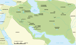
The Persian Achaemenid Empire
|

|
The Persian Achaemenid Empire
|

|
The Persian Achaemenid Empire
|

|
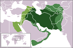
Map of the Empire of Alexander
|

|
Map of the Empire of Alexander 334-323 BCE
|
|
Map of the Empire of Alexander (Norwegian)
|

|
Hellenistic world in 200 BCE
|

|
Indo-Sassanide Empire
|
|
The Persian Sassanian Empire (226-650) in 602 to 629, Strokes: Under Sassanid military control.
|
|
Sassanide Empire
|

|
Sassanide Empire
|
|
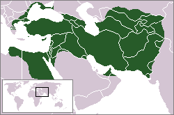
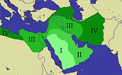
Expansion of the Caliphate: I: Muhammad; II: Abu Bakr; III: Omar and IV: Othman
|
|
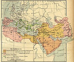
Caliphate around 750
|
|
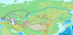
Map of the Western (purple) and Eastern (blue) Göktürk Khaganates at their height, ca. 600 CE. Lighter areas show direct rule; darker areas show spheres of influence.
|

|
The region around 1000
|
|
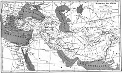
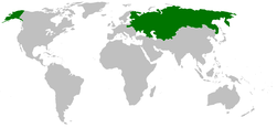
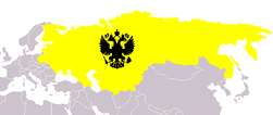
Russian Empire
|

|
The Russian Empire in 1866
|

|
History of the Russian Empire (in German)
|

|
Central Asia in 1900
|
|
Russia in 1912
|

|
Russia becomes the Soviet Union in 1922 and in 1924 parts of Buchara and Pamir, Russian since 1873, became part of Russia inside the Soviet Union. In 1929 Tajkikistan becomes a separate member republic of the Soviet Union
|

|
Evolution of the Soviet Union
|
|
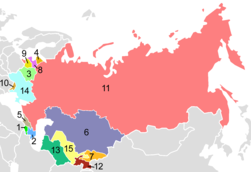
The republics of the USSR
|

|
Tajikistan in the USSR
|
| [[|border|251x400px]]
|
Map of the 1974 geographic location of various ethnic groups within the Soviet Union
|

|
Soviet Union administrative divisions, 1989
|
Satellite maps
Notes and references
General remarks:
- The WIKIMEDIA COMMONS Atlas of the World is an organized and commented collection of geographical, political and historical maps available at Wikimedia Commons. The main page is therefore the portal to maps and cartography on Wikimedia. That page contains links to entries by country, continent and by topic as well as general notes and references.
- Every entry has an introduction section in English. If other languages are native and/or official in an entity, introductions in other languages are added in separate sections. The text of the introduction(s) is based on the content of the Wikipedia encyclopedia. For sources of the introduction see therefore the Wikipedia entries linked to. The same goes for the texts in the history sections.
- Historical maps are included in the continent, country and dependency entries.
- The status of various entities is disputed. See the content for the entities concerned.
- The maps of former countries that are more or less continued by a present-day country or had a territory included in only one or two countries are included in the atlas of the present-day country. For example the Ottoman Empire can be found in the Atlas of Turkey.
- ↑ Romanization: Tojikiston - Jumhurii Tojikiston.
- ↑ {{romrus|Tadzhikistan - Respublika Tadzhikistan.
Entries available in the atlas
- General pages
- World
- Continents and oceans
- Themes
- Historical eras
- States with wide recognition
- States with limited recognition
- Dependencies and other overseas territories
- Country subdivisions
- Belgium
- China (mainland)
- India
- Pakistan
- Spain
- United Kingdom
- United States
- Other
- Disputed subnational territories
- Other regions
- Cities
- Former sovereign states
- Former dependencies and overseas territories
- Former disputed territories
Maps of divisions
This section holds maps of the administrative divisions.
References
 Article Images


