File:Kent Cinque Ports.svg - Simple English Wikipedia, the free encyclopedia
 Article Images

Original file (SVG file, nominally 1,700 × 1,212 pixels, file size: 163 KB)
File history
Click on a date/time to view the file as it appeared at that time.
| Date/Time | Thumbnail | Dimensions | User | Comment | |
|---|---|---|---|---|---|
| current | 19:57, 8 October 2017 | | 1,700 × 1,212 (163 KB) | Ras67 | frames removed and cropped |
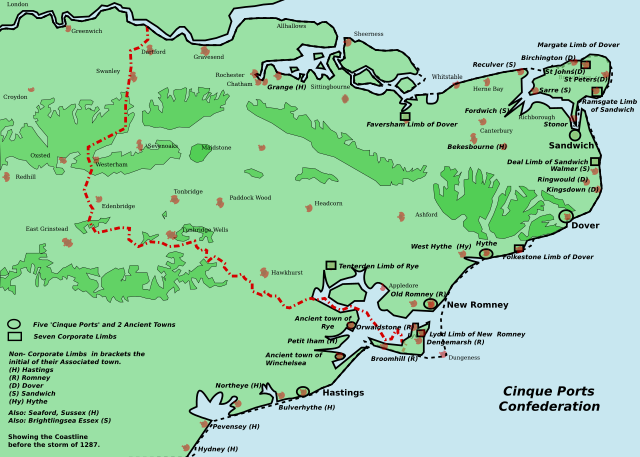
| 14:26, 25 June 2007 |  | 1,839 × 1,207 (182 KB) | ClemRutter | == Summary == {{Information |Description= This ia a map of the Cinque Ports in Kent and Sussex. All seven of them and their 7 limbs and many of the associated limbs. In 1287, the storm caused the silting up of the channel of the River Rother. The map was |
File usage
The following page uses this file:
Global file usage
The following other wikis use this file:
- Usage on ar.wikipedia.org
- Usage on cy.wikipedia.org
- Usage on da.wikipedia.org
- Usage on en.wikipedia.org
- Usage on eo.wikipedia.org
- Usage on es.wikipedia.org
- Usage on fi.wikipedia.org
- Usage on fr.wikipedia.org
- Usage on it.wikipedia.org
- Usage on ja.wikipedia.org
- Usage on ko.wikipedia.org
- Usage on lv.wikipedia.org
- Usage on nl.wikipedia.org
- Usage on no.wikipedia.org
- Usage on ru.wikipedia.org
- Usage on rw.wikipedia.org
- Usage on sh.wikipedia.org
- Usage on sl.wikipedia.org
- Usage on sv.wikipedia.org
- Usage on zh.wikipedia.org
This file contains additional information, probably added from the digital camera or scanner used to create or digitize it.
If the file has been modified from its original state, some details may not fully reflect the modified file.
| Short title | Kent Cinque Ports |
|---|---|
| Width | 1700 |
| Height | 1212 |